Location of the cache site (labaz) of the Dyatlov group
25 January 2023. Ural Pathfinder. Author Aleksander Konstantinov
To date, almost all significant places of the tragedy of 1959 associated with the death of nine hikers led by Igor Dyatlov in the mountains of the Northern Urals are known. Until recently, it was not possible to find the labaz (this term was originally used by the hikers themselves, for example, in the diary of Zinaida Kolmogorova, and after that by the investigators and searchers) - the place of laying food by hikers before the ascent to Mt Otorten, as well as the place of their overnight stay from 31 January to February 1st.
During the search work, the labaz was found on March 2, 1959, a few hundred meters from the searchers camp along the maps drawn by the hikers themselves. Here is how Yuri Yarovoy describes it in his fiction book based on documentary events: "Found the labaz of the Sosnov group. The labaz was almost next to us, a little higher up Malik river. In the middle of the clearing rose a snow pyramid topped with a pair of skis. One could only wonder how this pyramid had not been noticed before - our ski track was ten meters away" ("The highest category of difficulty" 1966). Pyotr Bartolomey, a participant in the search, recalls that the path from the search camp went north to the pass (in the interview he said higher from the camp, which corresponds to the northern direction on the diagram under the discussion), and the labaz was to the left of the path if you climb to the pass. This is not contradicted by another searcher, Yuri Sahnin, who notes and adds that "There, one road rises, from the place where the camp was on Auspiya, there was their labaz somewhere nearby. This the only reasonable place to go to the pass. Everything else is through the thicket, through the forest, but here you quickly enough go out into the open space... But on the pass - there was just a bald spot and we walked along the edge of the forest, and nowhere did we particularly cling to the trees.
In the protocol of the inspection of the storehouse from the criminal case, the exact distances are not indicated, but it is noted that "... in the upper sources of Auspiya river, under the pass of the river Lozva found labaz (storage site) of Dyatlov group." (case files 8). According to the report of the members of the route-qualification commission of the All-Union Tourism Section "The labaz was found only 300m from the base camp in the forest, 100m from the bank of Auspiya." (case files 38). According to the testimony of Evgeniy Maslennikov "the upper reaches of Auspiya, 400m from the search base camp, was found the Dyatlov group labaz" (case files 220). It is also known that this place was located 500m below the border of the forest and 1000m from the landing site (testimony of Evgeniy Maslennikov, case files 71 и case files 73). In addition, the coordinates of its location were determined (radiogram dated March 2, 1959, case files 167), but they are lost or not found. The surviving information about the location of the labaz did not allow modern researchers to find it on the ground for a long time. Difficulties in finding the place were due to the lack of accurate data on the location of the searchers camp, as well as confusion in the name of the watercourses. The searchers believed that their camp was located on Auspiya river, while it was located on a tributary of this river.
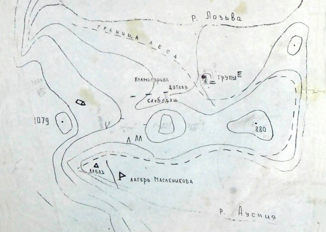
Scheme of the area of the tragic events of 1959 from the criminal case
- 2 -
The difficulties in finding the labaz arose due to changes in vegetation, since over the past more than half a century, the vegetation that is captured in the photographs of 1959 has changed due to the growth of trees, in addition, other changes could occur associated with the appearance of new tree and shrub vegetation or some part of the trees could die, for example, as a result of a wind or snowfall. Some researchers, after unsuccessful attempts, came to the conclusion that it is "practically impossible to find the labaz, since there is not a sufficiently accurate amount of necessary information for this" (Borzenkov, 2019).
Despite conflicting and insufficient data, the location of the labaz was found on August 11, 2019 during the expedition of the foundation "In Memory of the Dyatlov Group" as follows. The leader of the expedition, Yuri Kuntsevich, indicated the location of the winter camp of the searchers, which, in his opinion, was in the same clearing where the expeditions of the foundation are always based (according to Aleksander Alekseenkov, based on his own research in August 2022, the winter camp of the searchers was located a little further - 60m north-west of the clearing in question). Taking this information as a starting point, the expedition member Aleksander Konstantinov examined two possible locations for the labaz, which are given by its location relative to the searchers camp (300m and 100m, as well as 400m and 100m). In both cases, it was not possible to find the location of the labaz, but the forest conditions in the second place (400m and 100m) were very similar to those captured in the photographs of 1959, so the search area was increased.
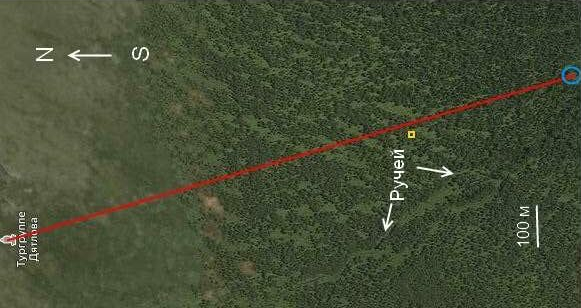
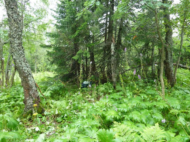
As a result, at a distance of 400m from the clearing, where the expeditions of the Dyatlov foundation are always based, and 160m from the nameless stream, the location of the labaz was found, which, despite the past 60 years, was quite well identified by characteristic trees and other signs. The labaz has the following coordinates 61°44′48.1" North latitude and 59°26′58" East longitude (World Geodetic Reference System WGS-84).
In August 2022, members of the expedition of the foundation "In Memory of the Dyatlov Group" conducted a survey of the labaz. This survey found:
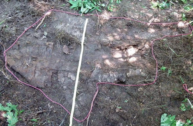
- birch bark flooring,
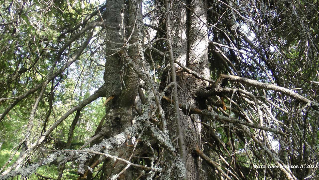
- four traces of partially felled and partially broken branches on a fir about 150 years old,
- numerous breaks of branches on a neighboring fir that is over a hundred years old,
- a small pile of dry branches under the same fir,
- the remains of a log next to the flooring,
- old codominant fir and spruce.
- 3 -
Could not find any metal objects or the location of the campfire of the group.
Birch bark flooring has an irregular shape 1.5m long and 1m wide...
... found directly at the place of laying the products (aka labaz).
Mapping of trees was carried out, cores were taken from some trees, minimal environmental measures were taken (an information plate was placed on the tree and a path was marked for movement in the immediate vicinity of the labaz), photo and video filming was carried out.
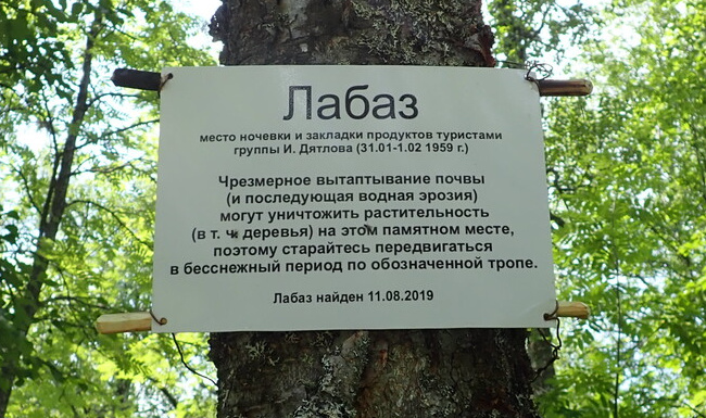
An information plate placed at the labaz (photo by Teodora Hadjiyska, August 3, 2022).
- 4 -
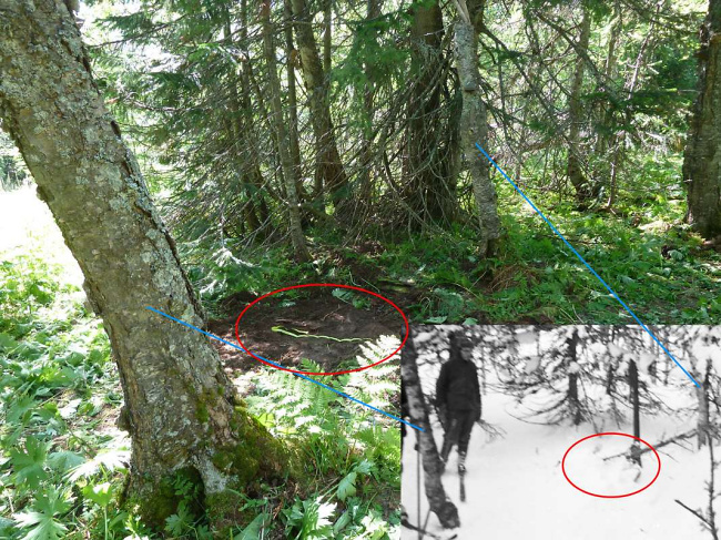
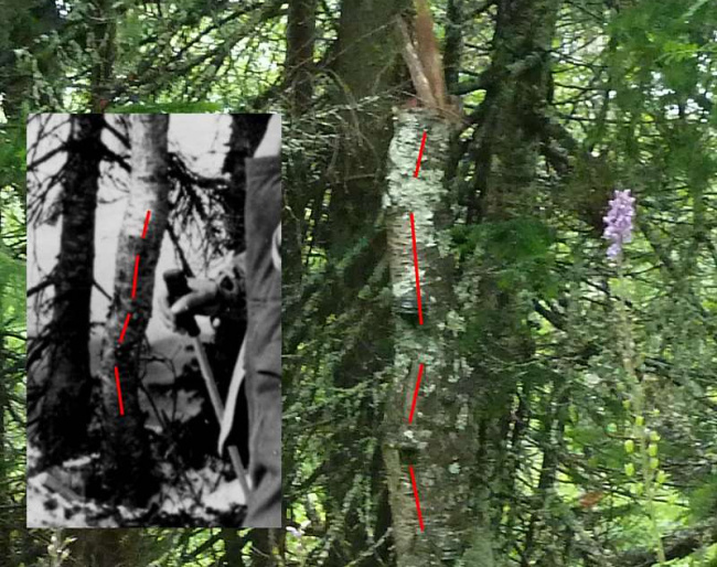
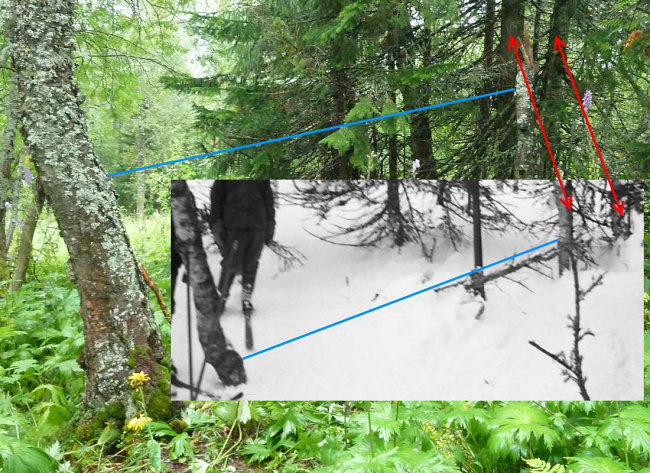
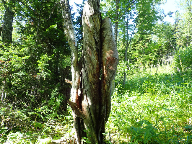
The location of the labaz is identified by two characteristic birch trees, one of which died, but continues to stand in the form of a dead remains of a trunk 2.2m high. Despite it has been 60 years, the birch trees are still recognizable by the characteristic bends of their trunks...
...the relative position of the vegetation surrounding them, the characteristic combination of open and forested areas and the terrain. In addition to these two birches, old-growth two-peaked fir and spruce located south of the dead birch, two fir trees northeast of the old living birch (one of the characteristic birches mentioned above) and other trees have been preserved. In the background of some photographs from 1959, there is a fairly open area, which to some extent has survived to this day. In one of the photographs from 1959, taken by the hikers themselves (a photograph with Nikolay Thibeaux-Brignolle and Aleksander Kolevatov), a short gap is visible on the right side, behind which distant mountain slopes (the same photograph shows at least one of the surviving fir, mentioned above, northeast of the old living birch). This gap can also be seen in modern photographs (the gap is located on the right side of the photo), but the distant mountains are not visible due to the grown trees and (or) due to the fact that the leaves of the trees interfere, however, the right slope of the river valley is located in that direction. Auspiya, which is visible in a photograph taken by the hikers in 1959.
A flooring made of birch bark was found under a layer of turf 2-3 cm thick between two characteristic birch trees. In addition to the main flooring measuring 1.5m x 1.0m, a small piece of birch bark about 20 cm x 20 cm in size was found next to it. Possible doubts about the preservation of birch bark over such a long period of time can be dispelled by the following arguments. Novgorod birch bark letters have survived to this day from the 11th-14th centuries, which indicates the possibility of preserving birch bark not only for decades, as in our case, but even for several centuries. In addition, the labaz was found on the border of crooked forest and dark coniferous forest, where the duration of the growing season is relatively short, and, consequently, there is a relatively short period favorable for the processes of decay and decomposition of organic substances.
- 5 -
In the protocol of inspection of the labaz it was noted that food and other objects were lined with cardboard, however, Yuri Yudin, the tenth hiker who, due to illness, could not complete this trip, noted in 2012 that "... of course there could not be cardboard there, because it's too heavy." Considering this, as well as the fact that birch bark is not mentioned in the inspection protocol, it can be quite reasonable to assume that there was a mistake made when drawing up the protocol, when the birch bark, for some reason, was written down as cardboard.
According to one of the authors of this article (Shamil Sabirov), the bark was torn off and put on the snow by searchers for counting and weighing products so that nothing was lost in the snow, which one can hardly agree with, since the bark is located exactly in the place where the products of the hikers were located, and if the products were moved, then the bark would be near this place. Moreover, at the time of the extraction of products, captured in the photographs of 1959, no bark is visible next to the snow pit from which the products are removed. Four partially cut and partially broken branches of fir (fir №19) are at a height of approximately 3m to 4m on one side of this tree. About the same height are the broken branches on the neighboring tree (fir №18), also on one side of the tree.
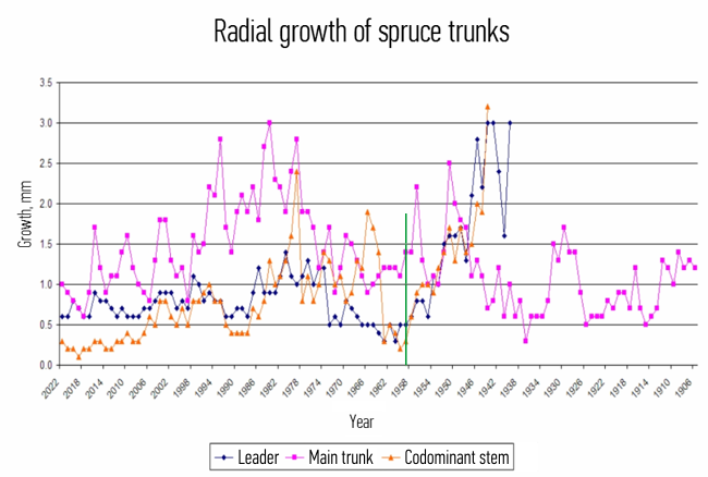
Search with two metal detectors (Garrett Ace 150 and Garrett Ace 400i) in the area up to 15 m around the birch bark flooring (this area was examined almost twice - once by each metal detector) did not give any results. Also, a limited search for the remains of a campfire turned up no results. A pile of dry branches up to 3cm thick was found under fir №18 a few meters from the birch flooring. The remains of a log, most likely harvested by the hikers, was found in the immediate vicinity of the birch flooring. Apparently, it is this log that can be seen near the labaz in the photographs from the search work. Analysis of the cores of the codominant spruce showed that the formation of its two new trunks is associated with the inhibition of the growth of the main trunk, which occurred for about 60 years, which led to its death and the emergence of two new trunks from side branches.
Taking into account all other factors, it can be quite reasonably asserted that the mechanical impact on these trees was made by the hikers in 1959 when harvesting branches for flooring under the tent and during the construction of the labaz. The above diagram clearly shows how, until 1959, there was a gradual slowdown in the growth of spruce lateral branches, which is typical for lateral branches located in the lower part of the tree crown, while later their growth increased, which is associated with growth inhibition and (or) death of the main trunk of the spruce.
- 6 -
The location of the labaz in this place is not accidental and is explained by the following circumstances. From the group diary of the Dyatlov group, it is known that on January 31, 1959, at the end of the day, they reached the border of the forest, located on the southern slope of the eastern spur of Mt Kholat Syakhl, and began to descend south in search of a suitable place to spend the night. Since a narrow clearing extends from the labaz to the border of the crooked forest and mountain tundra in the direction from south to north (magnetic azimuth), it can be fairly reasonably assumed that the choice of this place is associated with the movement of the hikers from the border of the forest to the place of their future overnight stay along this clearing, where there was a stronger wind crust, and where the tree and shrub vegetation did not interfere with skiing, and this route also agrees very well with the direction of their movement mentioned in the group diary.
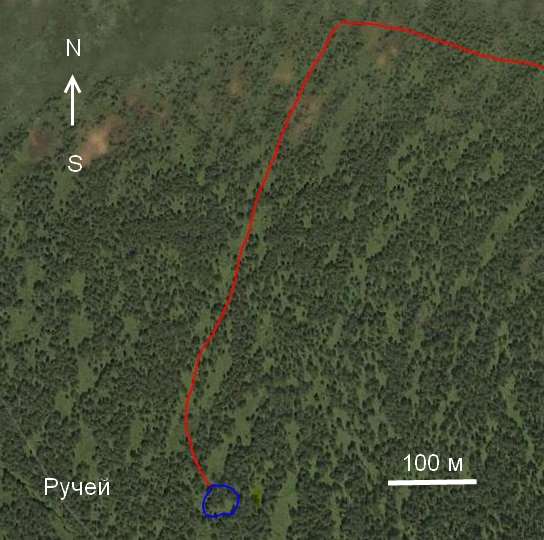
The hikers did not go down any further into the zone of dark coniferous taiga, since there was no wind crust in this zone, and skiing was complicated by deep loose snow, and the clearing along which they moved ended. The labaz is located on the border of two natural zones: crooked forest and dark coniferous forest, and this is no coincidence, since it was the best place where there was still a fairly strong wind crust, and where there was a minimum but sufficient amount of firewood for a camp fire and the heating stove.
The overnight campsite of the Dyatlov group from January 31 to February 1, 1959 and the location of the labaz is confirmed by the following circumstances:
- In accordance with almost all the distances indicated in the case files, with the exception of the distance from the stream (160m, not 100m). The labaz is located 400m from the clearing along the stream, most likely created by the searchers during the construction of a landing site near their camp (this landing site was not used for its intended purpose). The labaz is located 1000m from the landing site (and this landing site was located in the mountain tundra and was used for its intended purpose), which is located near the memorial remnant and 500m from the forest border. In addition, the distance from the path to the labaz (10m), indicated by Yuri Yarovoy, practically coincides. This allows us to reasonably assume that the modern trail leading from the clearing, where the expeditions of the Dyatlov Foundation is always based, to the famous memorial remains was created in 1959 during the search work, when the searchers had to constantly trample the path, and which was laid by them along the shortest distance, taking into account the characteristics of the terrain and its passability. The discrepancy between the distance from the stream to the labaz can be explained by inaccuracy or measurement error, perhaps this distance is determined by eye due to its small length. The found place does not contradict the recollections of the searchers Pyotr Bartolomey and Yuri Sahnin about the location of the labaz.
- The presence of preserved characteristic trees, identifiable from photographs of the hikers and photographs from search operations. At the same time, temporal changes among coniferous trees are quite significant, which requires a thorough additional examination of the discovered site in order to explain the picture observed now.
- The coincidence of forest conditions - the border of the zone of dark coniferous forest and the zone of crooked forest.
- The coincidence of the relief and the location of open and overgrown areas of the terrain.
- Finds of traces of hikers activities at the campsite (flooring from birch bark, cuts and broken branches on two fir trees, allegedly a harvested log, a bunch of dry branches, codominant spruce and fir). At the same time, finding the camp fire of the group is a rather important.
- An understandable and logical choice by the hikers of this particular location: access along a clearing and a spot at the border of two zones, where the wind crust ends and there is plenty of firewood.
At the end of the article, we would like to express gratitude to all the participants in the 2022 expedition and its organizers for their support and assistance in our research.
A. V. Konstantinov,
Y. K. Kuntsevich,
A. A. Alekseenkov,
O. Y. Nikulin,
O. A. Nikulina,
A. V. Komanev,
T. A. Hadjiyska,
S. K. Sabirov.

