Determining where the Dyatlov group's tent was found in 1959
October 9, 2024, Aleksander Konstantinov
1. History of the search for the location where Dyatlov group tent was found
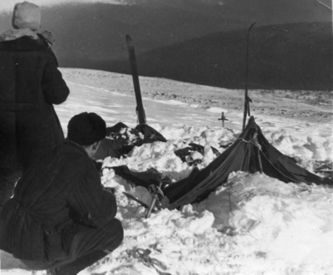
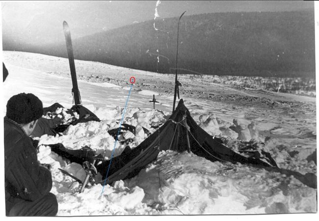
It is a well known fact that during the search operation Boris Slobtsov and Mihail Sharavin found the tent on February 26, 1959. The tent was located on an open mountain slope of the north-eastern spur of Kholat Syakhl (fig. 1).
Fig. 1. Partially excavated hikers' tent at the site of discovery. Photo from the search in 1959.
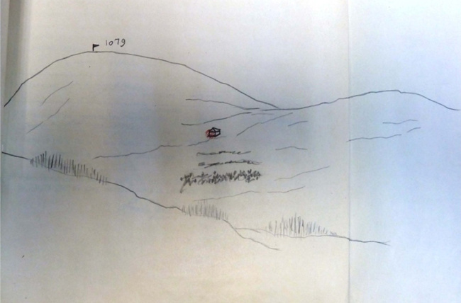
During the search operations, the coordinates of the tent were not determined (if they were determined, they were lost), and in the protocol of the tent inspection, its location is indicated without detailed reference and with errors: "The overnight stay is on the north-eastern slope of the height of 1079 at the source of the Auspiya River. The overnight stay is 300 m from the top of the mountain 1079 at a mountain slope of 30°" (Fig. 2). In this case, one of the errors is that the tent was not located at the source of the Auspiya River and, therefore, not in the valley of this river, but in the valley of the Lozva River.
Fig. 2. Location of the tent on the north-eastern spur of Mount Kholat Syakhl, Case files 81
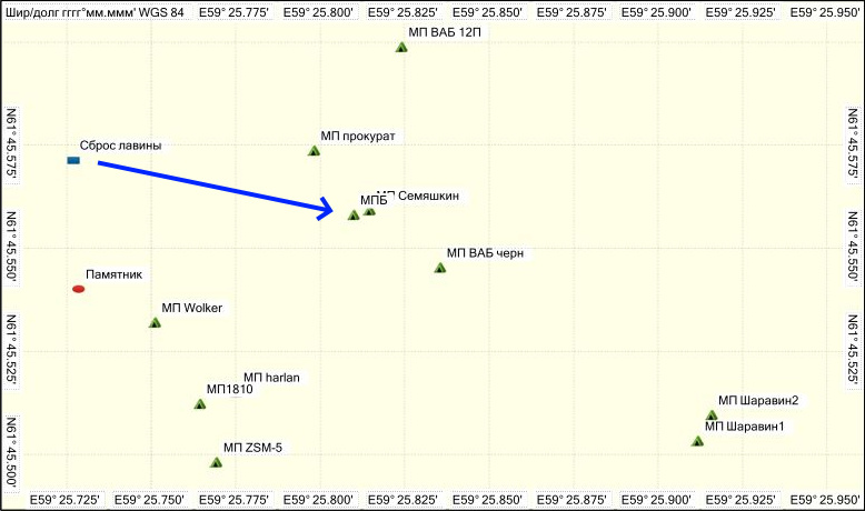
The location of the tent (TL) was also recorded in several photographs, which were used by modern researchers to determine its location. The photographs of the hikers themselves only show (allegedly - ed. note) the moment of preparing the site for the tent, taken during a snowstorm, and which do not show the surrounding area, so they cannot be used to determine the TL. The lack of TL coordinates, as well as the lack of reference of this place to landmarks, led to the fact that the TL was lost. The first attempts to determine the TL were made in the spring of 2001 during an expedition led by the director of the state nature reserve Igor Popov, in which the tenth participant of the expedition of Igor Dyatlov's group, Yuri Yudin, and the searcher Mihail Sharavin took part, who, as noted above, together with Boris Slobtsov first discovered the tent during the search in 1959. Despite the fact that there was still snow cover on the slopes, which could have helped in identifying the TL, Mihail Sharavin was unable to indicate the exact location of the tent. He designated a certain point on the terrain, which turned out to be incorrect and located at a distance of 130 m from the true location (Fig. 3), although he himself believed that the error could be no more than 50 m (see below).
- 2 -
Fig. 3. Placement of the main TL variants. TLB – TL according to Buyanov (his latest version at the moment, before that he believed that the true TL is located near the Mihail Sharavin cairns – TL Sharavin 1 and TL Sharavin 2), the TL symbol harlan is covered by the inscription TL 18.10 and is located under the number 8, or more precisely under the lower circle of this number. The blue arrow is the direction of the avalanches, the arrow points to TL Buyanov. The "monument" is an awkward sculpture installed by enthusiasts several years ago."
In 2009, Mihail Sharavin made another attempt to find the TL, but it was also unsuccessful. Here is what he wrote in his report about this attempt. "The task for August 11 is to clarify the location of the tent that we discovered on February 26, 1959, on the slope of Mount Kholat Syakhl. We had to go from the outlier (Boot Rock - ed. note) in the direction of the northern spur of Mount Kholat Syakhl, as in the winter of 1959, when the corner of the tent sticking out from under the snow was discovered 50-70 meters to the left of the direction of movement. The difficulty is that the landscape and the nature of the terrain are very different in winter and summer. I already had to participate in determining the supposed location of the tent in the spring of 2001. Then two cairns of stones were laid out on the terrain, marking this place. But now we have additional information, in the form of azimuths determined by the head of the search at the pass in 1959, Evgeniy Maslennikov. Comparing this information with my intuitive understanding of the area, I am inclined to say that the supposed location of the tent of the deceased group should be within a radius of 50 meters from the place previously designated by the cairns" (Taina.li).
Later, other searchers visited the pass, for example, Valentin Yakimenko, but they were also unable to indicate the exact location of the tent. All this indicated that determining the location of the tent is not such a simple task, which, in fact, is confirmed by the history of determining this place. As the Dyatlov group topic became popular in the media, more and more people began to join the search for the MP. As a result, various versions of the MP began to appear like mushrooms after the rain. There is no point in mentioning them all, since the errors in determining the location were quite large. But it makes sense to recall some of them. The simplest was done by E. Buyanov (the author of the well-known version of the avalanche), who, without any calculations, declared that the true MP is located practically in the same place (within a radius of 50 m) where M. Sharavin determined it.
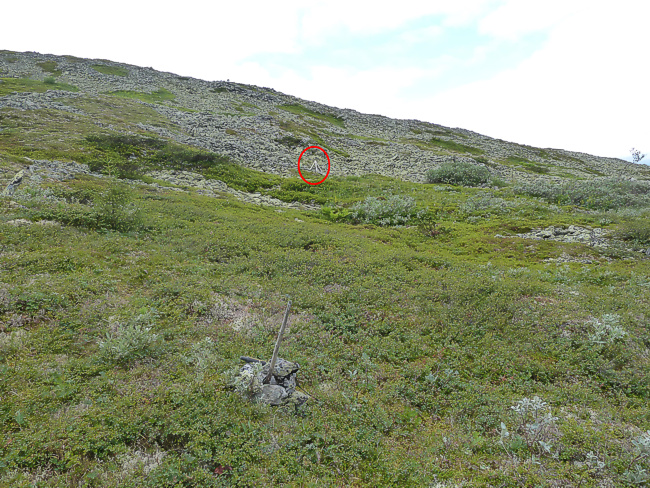
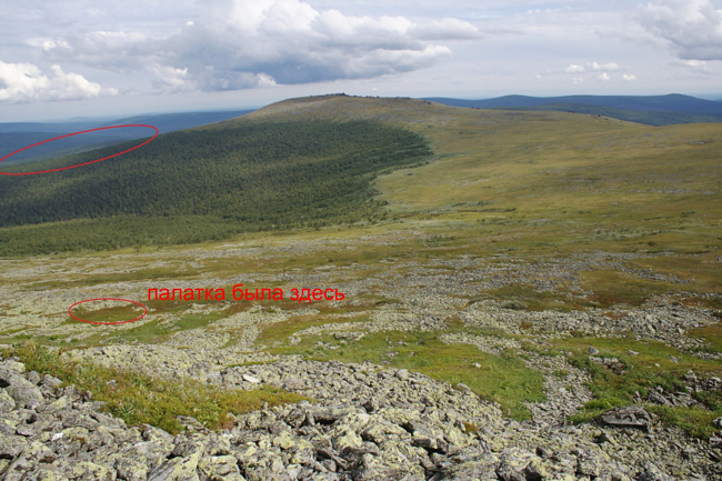
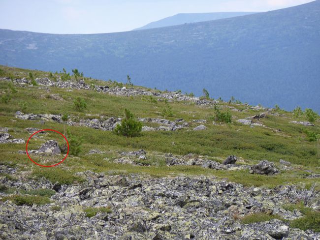
However, the most serious research on this issue was conducted by Vladimir Borzenkov (the author of the infrasound theory), who managed to prove that Sharavin's TL is definitely incorrect. Vladimir Borzenkov noted that Sharavin's MP does not agree with the photographs from the search operations, which show a "bump visible behind a spur" (Borzenkov. About Buyanov's version. 2009), located to the northeast of the tent. Based on this landmark, they were given a new approximate location for the tent further up the slope, which was marked with a stake and was given the name TL VAB drafts (Fig. 4)
Fig. 4. TL VAB drafts. In the foreground is the same pole marked in the TL VAB drafts. In the red oval is visible the pyramid installed by Evgeniy Buyanov on his TL. Photo by Aleksander Konstantinov July 22, 2023
- 3 -
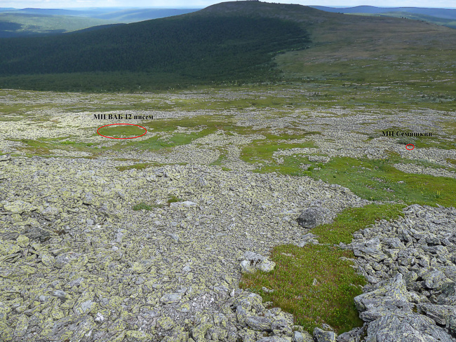
Later they were given a more precise location of the tent, and it was shown in the photo (Fig. 5), and they were also given the coordinates of this place: "… "My" location N = ХХгрХХ,542` ; E = ХХгрХХ,765'; H = 2965 ft (903,7 m) (I have an American GPS, it gives the altitude in feet. XX – values that completely coincide. Since Yuri Kuntsevich, as the host of the "event", asked "not to show off the numbers", I am fulfilling this agreement)" (Borzenkov. About Buyanov's theory. 2009). Apparently, these coordinates in deciphered form look like this: 61 ° 45.542 ґ N 59 ° 25.765 ґ E, and if this is correct, then the TL VAB 12 letters should be located in the immediate vicinity of the TL Wolker or coincide with it. At the same time, these coordinates do not significantly coincide with the coordinates of the TL VAB 12 letters, which is indicated by the author of this TL himself in his own photograph (Fig. 5).
Fig. 5. Location of the tent according to Vladimir Borzenkov (TL VAB 12 letters). Photo by Vladimir Borzenkov, all notes made by him. The large red oval marks the very same "hillock visible behind the spur".
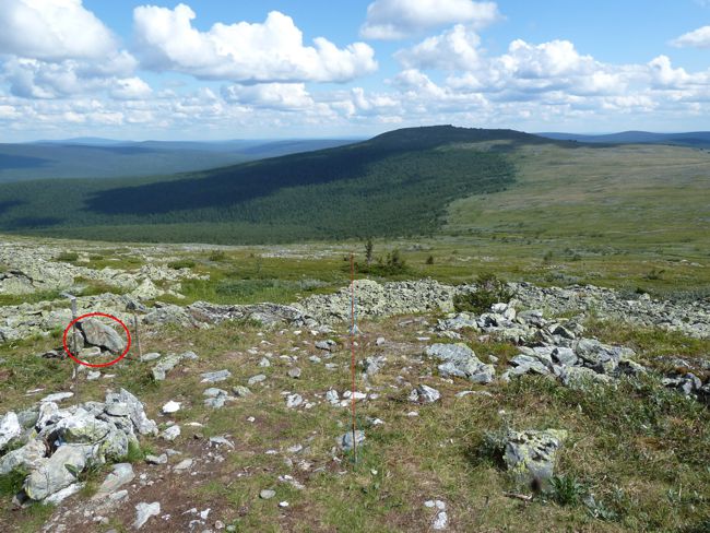
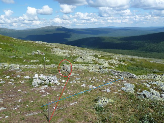
In 2023, I found this TL on the ground (Fig. 6) and determined its coordinates with an accuracy of no worse than ± 5 m. It is according to these coordinates that the TL VAB 12 letters was plotted on the TL diagram above (Fig. 3). It is clearly visible that this TL is located quite far from the Wolker TL, and is located 170 m from TL 18.10, the true TL. (ed. note - the author of this article calls it like this, "true" TL).
Fig. 6. TL VAB 12 letters, found on the site in the summer of 2023. TL according to Semyashkin is indicated on the right (small red oval). Photo by Aleksander Konstantinov, July 22, 2023.
In 2010, Semyashkin called his own TL, it appeared during a winter expedition led by S. Semyashkin, during which an experimental tent was installed, and it was installed in a slightly different place, indicated by V. Borzenkov: “slightly above the stake (approximate location of the tent according to V. Borzenkov, the so-called MP VAB drafts), about six meters and thirty meters to the north” (Sergey Vasilievich Semyashkin Report on the 2010 expedition). "The marker was installed (N 61.45.443; E 59.26.265) slightly below and to the right (about thirty to forty meters) of the supposed location according to Evgeniy Buyanov (St. Petersburg, author of the "avalanche theory") and fifty meters to the left of the location indicated by Vladimir Borzenkov himself, already taking into account the home adjustment" (ibid.).
- 4 -
In 2011, using photographs by Vladimir Borzenkov, a researcher with the nickname Wolker indicated his TL in a laboratory setting, using for the first time relatively small stones located on the north-eastern spur of Mount Kholat Syakhl as landmarks (the most famous of these are the so-called three Wolker stones). He believed that the location of the tent was determined with the accuracy of: "in the scattered spot of the probable location of the tent with a radius of no more than 20 meters" (Wolker. Addition to "another version of Walker". The Dyatlov group accident, 2011.), in fact, he was not very mistaken, since the true TL is located only about 35 m from his TL. It should be noted that it was this author who significantly improved the TL search methodology when he began to use landmark stones located close to the TL, since up to this point other TL authors had used only large relief elements (spurs, mountain peaks, large outliers, etc.) as landmarks. Subsequently, it was this researcher's approach - using small stones as landmarks - that made it possible to determine the TL with an accuracy of several meters.
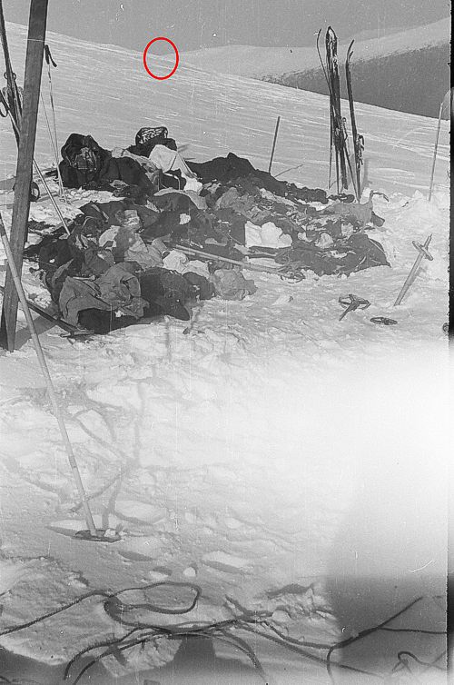
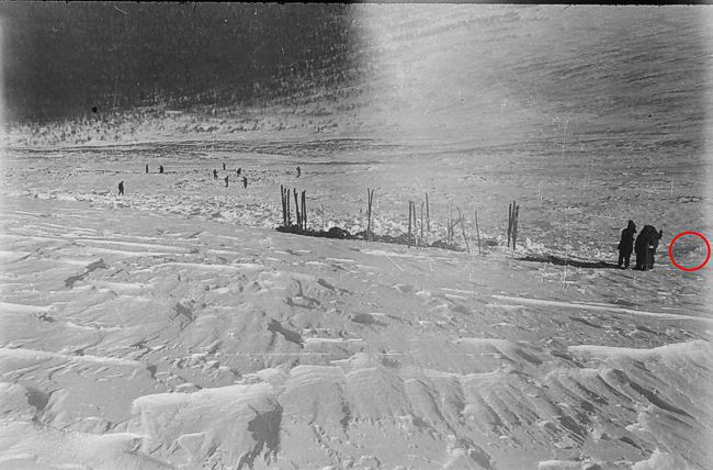
It should also be noted that TL ZSM-5 (author Timur Voskoboynikov), which was determined in office conditions before finding TL 18.10, is located only 25 m from the true TL. In addition, it was this author who indicated a simple and clear criterion for checking the correctness of the TL location relative to one of the elevations of the eastern ridge of Mount Otorten (Fig. 7). The essence of this criterion is as follows. In the presented photo, taken from the TL during the search in 1959, in the background you can see the slope of the north-eastern spur of Mount Kholat Syakhl, which overlaps the more distant slope of the eastern spur of Mount Otorten in the place (or very close to this place) where the more gentle and steep slopes of this ridge come into contact (this place is marked with a red circle). Using this criterion, you can very easily and quickly check the TLs of various authors, and it will immediately become clear that most of these TLs do not withstand the test of this criterion, by the way, even the very closely located TL Harlan (approximately 10 m) does not meet this criterion, which was calculated much later than TL 18.10, and, as it were, by more accurate methods, which is not at all the case (more on this in the next part).
Fig. 7. Timur Voskoboynikov’s criterion. The location of the near and far slopes when viewed from the true TL (explanation in the text). Photos from the search in 1959.
- 5 -
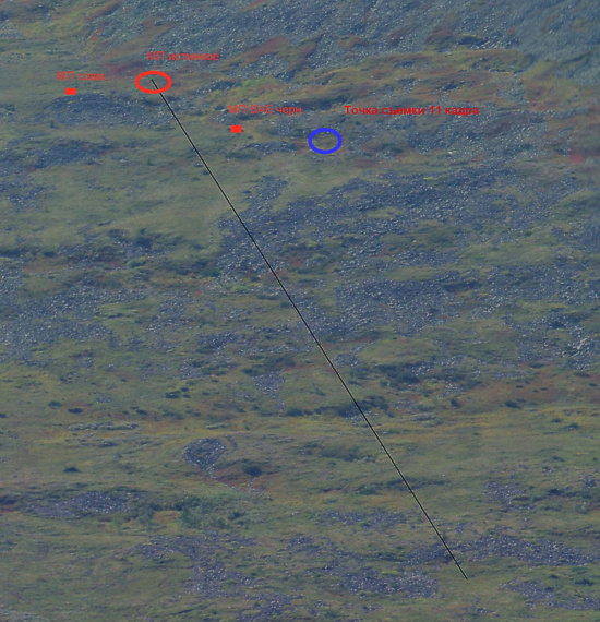
In the fall of 2012, a group of researchers consisting of ZSM-5 (Timur Voskoboinikov), Parf, Metallurk (Dmitry Kozyrev), Sasha KAN (Aleksander Koshkin), Malecon and Aleksandr (Aleksander Konstantinov) determined the true location of the tent – TL 18.10). Here is my post from October 9, 2012, where the zone of the true TL is shown for the first time (Fig. 8): "We found ourselves in a bit of a dead end because of the 11th frame from the FED, so we had to look for the point of its shooting. Thanks to Dmitry’s magnificent panoramic photos, the search was crowned with success (blue oval). Moreover, thanks to this panorama, it was possible to determine the true TL with a fairly high accuracy (red oval, the black line shows one of the lines I used to search for the TL)…" Taina.li
Fig. 8. Discovery of the true TL (red oval) on October 9, 2012. (in a few days this TL will be called MP 18.10). Photo panorama by Dmitry Kozyrev, 2012
On October 18, I determined the coordinates of this place, and it was named MP 18.10 (the name was invented by Sasha KAN): "Approximate coordinates of the center of a circle with a radius of about 10 m, within which the true TL is located: 61 degrees 45 minutes 30.82 seconds north latitude 59 degrees 25 minutes 45.97 seconds east longitude." (Taina.li). The following addition was made the following day: "An important addition to the coordinates of the TL 18.10, given the low accuracy of navigators, which, by the way, can change depending on various conditions, and also given possible errors in determining the coordinates of this TL in Google and given the high density of TL in this area, when identifying TL 18.10 on site, it is necessary to additionally identify this place using two photographs in which it was indicated. Let me remind you, just in case, that it was previously identified and indicated in Dmitry's photo panorama and in Sasha KAN's photo (copies of these photographs are posted in this topic)" Taina.li.
As it turned out later, after specifying the location of the tent on site in 2019 and in 2023, the first calculated coordinates of TL 18.10 (in office conditions, they are indicated above) turned out to be quite accurate: the discrepancy with the coordinates determined on site (65° 45' 30.7" N and 59° 25' 45.9" E) was only about 3 m, which is comparable to the navigator's error, i.e. in the fall of 2012, fairly accurate coordinates of the true TL were determined for the first time. All this allows us to say that the author of the true TL (TL 18.10) is a group of six researchers mentioned above, who identified this place in the fall of 2012, when the coordinates of this place did not yet exist, and it was first identified in photographs.
Some time after the discovery of TL 18.10, Evgeniy Buyanov moved his TL to a new location and installed it next to the Semyashkin TL. Here is what Evgeniy Buyanov said about his new TL on one of the forums on August 4, 2021: "... My ideas have always boiled down to exactly this assessment - somewhere within plus or minus 50 m with geometrically accurate constructions. And with estimates that did not take into account some components of errors, these errors increased by at least 2-3 times. I have been there, on the spot, more than once, and I understand the naivety of those "conclusions" (misadventures) of those who claimed that they managed to determine the location of the tent with an accuracy of several meters. Such "geometers" were wrong by a factor of 100, if not more. And their tent turned out to be completely different from where it actually stood - usually lower down the slope, where the slope is less steep). But where did they "drag it out" to please their ideas..."
- 6 -
On the pyramid that I installed near the "tent site" there was an indication (stamped on a plate) of the installation error in a circle with a radius of 50 m around the site of the pyramid. Mount Otorten is not visible from the tent site - this is evident from the photographs, and Boris Efimovich Slobtsov told me the same. Therefore, in particular, all "constructions" of the tent site, in the photos of which Mount Otorten is visible, are incorrect" (Pereval1959.kamrbb.ru). One of the strengths of Evgeniy Buyanov's research is that he involves professional experts in solving certain issues, so his version, until recently, was the most developed and substantiated. However, this very strength is, at the same time, his weakness, since he himself cannot understand some issues, for example, about the TL. More than 10 years have passed since the discovery of TL 18.10 (and during this time it was possible to understand even issues in which you are not an expert), but Evgeniy Buyanov continues to persist in his misconceptions about the accuracy of determining the TL.
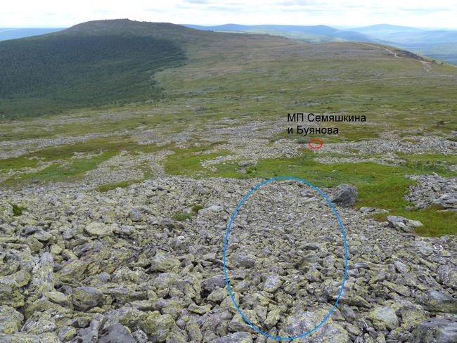
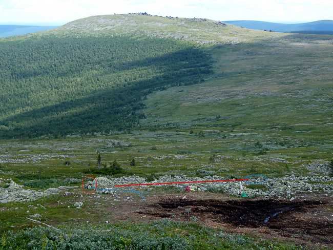
It is possible that the reason for Evgeniy Buyanov's moving his TL is also associated with the following circumstance. In 2023, up the slope from Buyanov's TL, I "discovered" clear traces of avalanches in the form of rounded stones aligned along the slope, and such stones were traced precisely in the direction of Buyanov's TL and Semyashkin's TL (Fig. 3 and 9). It should be noted that the stones in the upper reaches of the Auspiya River, where avalanches have been documented, look the same. As it turned out later, these stones were noted by Aleksander Alekseenkov several years ago, so this is not my discovery. This undoubtedly proves that avalanches near the TL are possible, but an avalanche was not the cause of the tragedy of 1959 (this is another story, so we will not touch on it here), it should also be noted that up the slope from the true TL there is no such evidence of avalanches, the stones are jagged and not aligned. By the way, this is one of the reasons for the need for an accurate definition of the TL, otherwise, if we recognize Buyanov's TL as the true MP, then his incorrect version may have, as it were, a serious justification.
Fig. 9. TL according to Buyanov and TL according to Semyashkin relative to rocks affected by snow avalanches (in the blue oval). Photo by Aleksander Konstantinov, July 22, 2023.
During the investigation conducted by the Sverdlovsk Region Prosecutor's Office in 2019 and 2020, another version of the TL was introduced, which was determined with a declared accuracy of ± 50 m, the coordinates of this TL were published by Natalya Varsegova on the forum taina.li. In fact, this TL is located at a distance of 115 m from the true TL.
- 7 -
2. Methods for determining the TL 18.10.
2.1. Hitory.
Methods for determining the TL 18.10. Part 1. History. and subsequent posts by Aleksander for December 12, 2023 All these studies were conducted in the fall of 2012 and were first published on the forum Taina.li.
2.2. Field research.
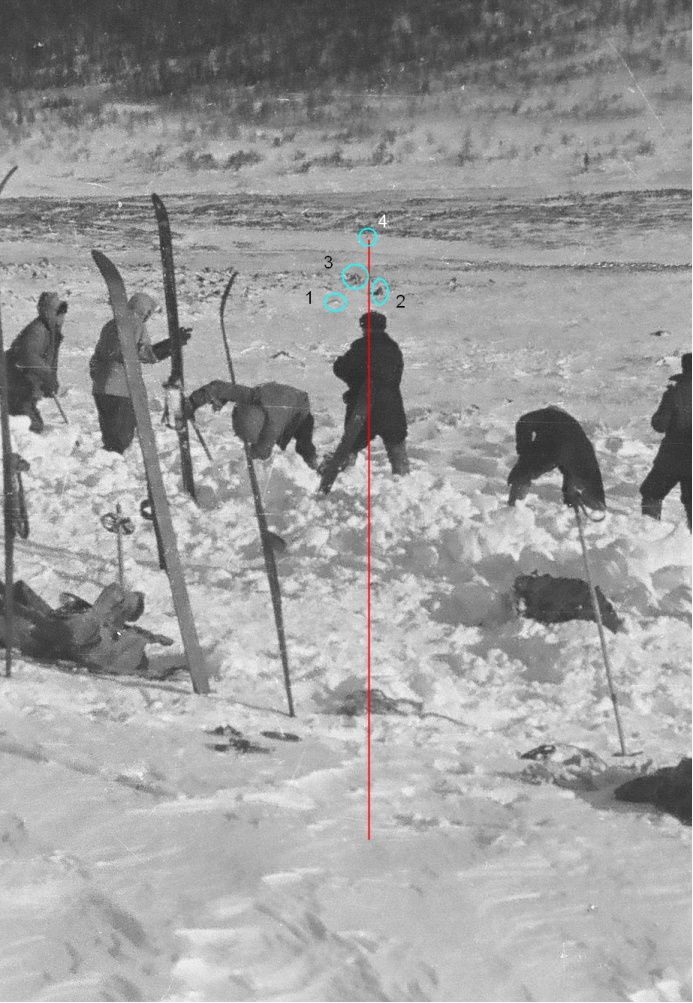
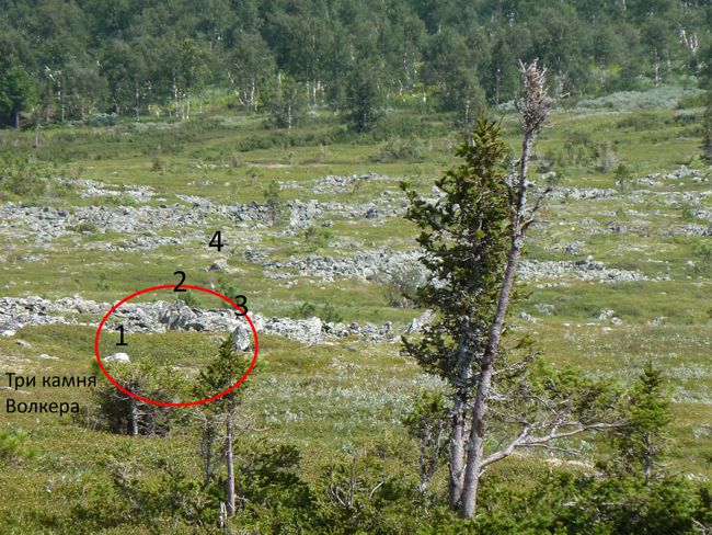
Field research related to specifying the location of the tent within ТЛ 18.10 were conducted in 2018, 2019 and 2023. To determine the location of the tent, perhaps the simplest and most accurate method that can be applied is based on the well-known axiom about two points and a line: through any two points there passes a line, and only one. To apply this method, it was necessary to find two clearly identifiable landmarks in the 1959 photographs with the tent, through which a line would pass, intersecting the tent or passing in close proximity to it. Moreover, to find the location of the tent, it was necessary to find two lines that would intersect on the tent or in close proximity to it. Taking into account the specifics of photographic images, the landmarks should be located not only in the central part of the photograph (due to distortion), but also one after the other, in a direction close to the optical axis of the lens. It is also necessary that the landmarks and the tent are located within the same relief element (for example, on the same slope) to avoid distortions associated with the mountainous relief. At present, after three Walker stones and the fourth stone from the third ridge have been identified, there are no problems with constructing the eastern line. Until recently, there were certain difficulties with constructing the northern line, since there are no well-identifiable landmarks in this direction that meet the above criteria.
1) Eastern line
Construction of the eastern line on a photograph from search in 1959 (Fig. 10).
Fig. 10. Fragment of a 1959 photo with reference stones (three Walker stones (1, 2, 3) and a fourth stone from the third stone ridge) and a line passing by the entrance to the tent. Photo from search in 1959.
- 8 -
Construction of the eastern line in a modern photograph (Fig. 11). This line is fixed by temporary stakes (blue ovals), and it passes to the right of the KAN stake and my temporary cairn (red oval), marking the center of the tent (with some obvious error, which was corrected in 2023 - see below), laid in 2019.
Fig. 11. The eastern line drawn through the 4th stone from the third ridge and between the 2nd and 3rd Walker stones, crossing TL 18.10. Photo by Alekasnder Konstantinov July 26, 2023.
The next zoomed photo (Fig. 12), taken with TL 18.10, shows the landmark stones used to construct the eastern line, and they are shown from exactly the same angle as they were taken in the previous photo.
Fig. 12. Photo of landmarks used to construct the eastern line. Three Walker stones and the 4th stone from the third stone ridge. Photo by Alekasnder Konstantinov, July 26, 2023.
- 9 -
2) Northern line
To construct the northern line, two landmark stones were used; the line passing through these stones intersects the tent almost through its southwestern corner (Fig. 13).
Fig. 13. The northern line drawn through the landmark stones (red oval). Photo from the search in 1959.
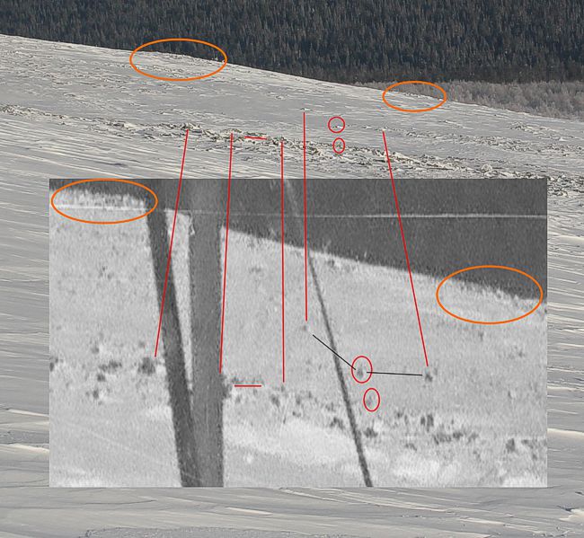
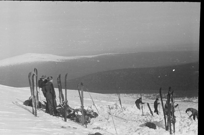
The landmark stones used to construct the northern line are quite difficult to identify in modern summer photographs, so to facilitate this process and for greater clarity, these stones have been identified in modern winter photographs taken by Aleksander Alekseenkov in 2014 (Fig. 14).
Fig. 14. Identification of landmark stones (in small red ovals) in a modern winter photograph (background photograph). A fragment of a photograph by Aleksander Alekseenkov (February 7, 2014) and a fragment of a photograph from the search operations of 1959 (Fig. 15) were used. Large orange ovals indicate characteristic rocky elevations, a short red horizontal line indicates the same stone, and long red lines connect the same characteristic stones. One of the characteristic stones in the 1959 photo is hidden by a ski, but it can be seen in another photograph with a view to the north from the tent (see Fig. 13).
- 10 -
Fig. 15. Photo from the 1959 search operations, looking north from the tent. After identifying the stones in a modern winter photograph, it is much easier to identify these stones in a modern summer photograph (Fig. 16).
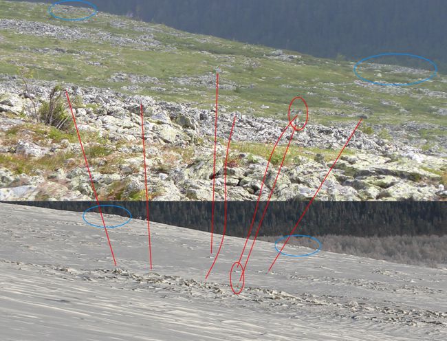
Fig. 16. Identification of landmark stones in a modern summer photograph. Fragments of photographs by Aleksander Alekseenkov (February 7, 2014) and Aleksander Konstantinov (August 5, 2018) were used.
- 11 -
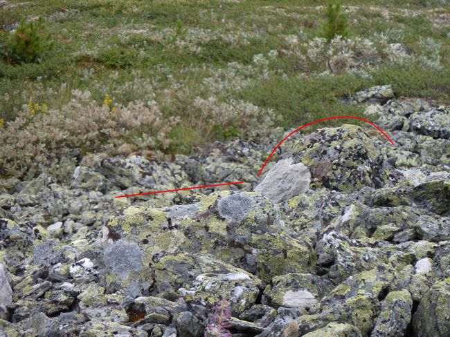
The red ovals contain landmark stones needed to construct the northern line, the blue ovals indicate characteristic rocky elevations, and the same stones are connected by red lines. This is what these stones look like up close (Fig. 17 and 18); the crocodile stone, since it is located on a stone ridge called the crocodile (Dyatlovpass1.ru) and stone 154, since it is at the apex of an angle approximately equal to 154 degrees; this angle is formed if three adjacent stones are connected with lines (this indicator can be used to check and confirm the correct identification of this stone; see Fig. 14 where these stones are connected with black lines).
Fig. 17. Crocodile stone (in the center of the photo, protruding stone) - the first landmark stone (closer to the tent), necessary for constructing the northern line. Photo by Aleksander Konstantinov July 26, 2023.
Fig. 18. Stone 154 - the second more distant landmark stone, necessary for constructing the northern line. Photo by Aleksander Konstantinov July 26, 2023.
The following photo shows the passage of the northern (red) and eastern (blue) lines on TL 18.10 (Fig. 19); in the red oval is the 2019 temporary cairn. It is clearly visible that the KAN stake is to the left of the northern line, which, as noted above, intersects the southwestern corner of the tent, i.e. this is the wrong place for the tent, if we are talking about accuracy within 1 m and if the stake marks the center of the tent.
- 12 -
Fig. 19. Intersection of the eastern (blue) and northern (red) lines within the TL 18.10. In the red oval is the 2019 temporary cairn, which marked the center of the tent.
In 2023, the location of the tent center was corrected, the old cairn was dismantled and a new cairn was laid (Fig. 20). In this photograph, in addition to the new cairn (in the red oval), the sections (between the poles) of two bearing lines are shown: eastern and northern (blue lines), as well as additional landmarks (two stones in the blue oval) with the distance from this landmark to the tent (red line) - 18.5 stones.
Fig. 20. Corrected position of the tent in 2023 - a new cairn (in the red oval) indicating the center of the tent. Blue lines are bearing lines. In the blue oval are the nearest landmark stones. The red segment is the distance from the landmark stone to the entrance to the tent. Photo by Aleksander Konstantinov July 26, 2023.
- 13 -
These stones are visible in the following photograph from the search in 1959 (Fig. 21). The above photograph also clearly shows how the vegetation cover at TL 18.10 and near it has degraded as a result of auto tourists visiting this place, and this happened in just 2-3 years.
Fig. 21. Two characteristic stones (in the red oval) near the tent
This is what these stones look like up close (Fig. 22).
Fig. 22. Two characteristic stones near the tent. The upper edge of the stones is shown in red lines.
Using the dimensions of the flat stone in the 1959 photograph, the distance to the tent (to the entrance to the tent) was determined, which was 18.5 stones in the 1959 photograph. Putting this distance on a modern photograph taken from approximately the same angle, it is clear that this method confirms the previously found location of the tent quite well using bearing lines. When taking direct measurements on the spot, it is necessary to take into account that the real line connecting these two stones with the tent does not run parallel to the frontal plane of the survey, but at some acute angle, so there will be some discrepancy between the length of the line determined from the photograph and measured on the ground.
3) Estimation of the error with which the position of the tent is determined.
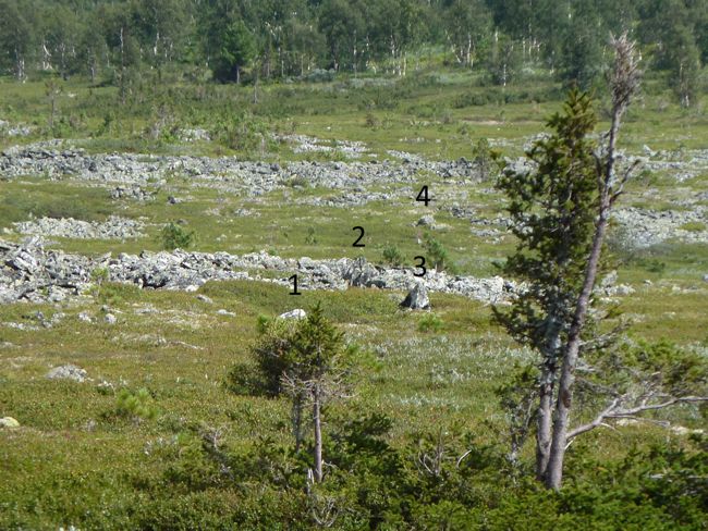
First, we will visually demonstrate the error in constructing bearing lines using the example of the eastern line. The following photograph (Fig. 23) shows how the position of the 4th stone changes relative to the 2nd and 3rd Walker stones when the observer moves 50 cm to the right, i.e. when constructing this line the error cannot be higher than a few centimeters.
Fig. 23. Estimation of the error in constructing the eastern line. 1, 2 and 3 are three Walker stones. 4 is a stone from the third stone ridge.
It is clear that after the observer has shifted only 50 cm to the right, the 4th stone is no longer between the 2nd and 3rd stones (compare this photo with the photo in Fig. 12). Now let us estimate the error in constructing the bearing lines using geometric constructions. It is known that three Walker stones are in front of the 1st stone ridge, which is located 200 m from the MP, the 4th stone is in front of the third stone ridge, which is located 350 m from the TL.
- 14 -
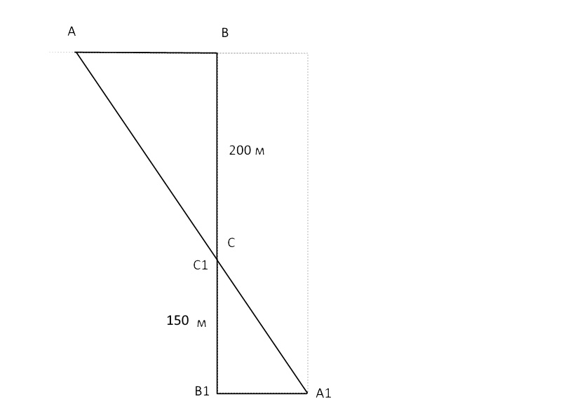
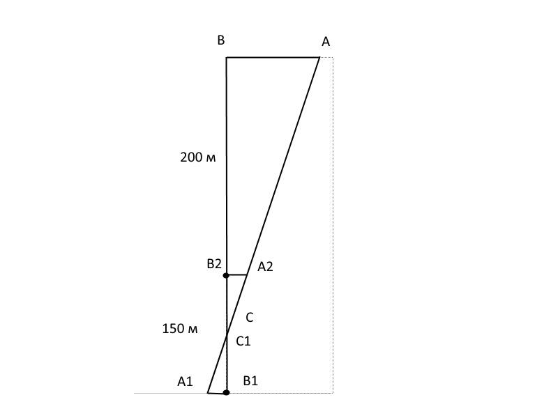
For simplicity of calculations we will assume that the reference stones are located at exactly these distances from the TL. When drawing bearing lines on photographs, one can make a mistake in choosing points, and this error, in the maximum case, is comparable with the horizontal dimensions of the stone itself. These stones were found on the ground and their sizes were determined, which do not exceed 0.5 m, i.e. this value can be taken as the maximum error. Let us calculate the deviation of the bearing line on the TL in the case where the maximum error (0.5 m) was made: a shift of the point at the 4th stone. In the following diagram (Fig. 24; the distances on the diagram are not maintained, since the illustration is given to demonstrate the essence of the calculations), at point B1 there is the 4th stone, at point C (C1) the eastern line passes between the 2nd and 3rd stones, at point B the line passes near the tent; line BB1 is the eastern line if it is constructed without errors. Let's find the error value (AB) if an error of 0.5 m is made in the area of the 4th stone (A1B1), i.e. an erroneous line (AA1) is laid. Using similar triangles (ABC and A1B1C1), we determine:
AB/A1B1 = BC/C1B1
AB = 200/150*0.5
AB = 0.67 m
Fig. 24. Calculation of the error in case of erroneous determination of the point in the area of the 4th stone
So, the error in this case will be 0.67 m.
However, an error is possible when constructing a line in the area of three Walker stones. Let us calculate the maximum error if errors are made both at the 4th stone (B1) and in the area of three Walker stones (B2) (Fig. 25), i.e. an incorrect line AA1 will be created.
AB/A1B1 = BB2+B2C1/C1B1
AB = (200 + 75)/75 * 0.5
AB = 1.8 m
Fig. 25. Calculation of the error in case of erroneous determination of points in the area of the 4th stone and three Walker stones
Thus, the maximum possible error in constructing a line in photographs can be 1.8 m, this is approximately true for the northern line as well, since the landmark stones used to construct it are located at approximately comparable distances (330 m and 200 m), and the stones themselves are approximately the same size. When conducting field research, the error in plotting lines using identified landmarks is significantly lower and can be no more than a few cm, since the length of the segment of bearing lines from the extreme landmarks to the TL is relatively small and is completely visible, i.e. significant errors are impossible with the correct construction of bearing lines, this is also visually demonstrated at the beginning of this section (Fig. 23).
- 15 -
Currently, the error in determining the location of the tent using bearing lines can be estimated within about 1 m (or 1-2 m), which is significantly less than the size of the tent itself. Thus, it can be considered that the determination of the tent begun in 2012 is complete, and TL 18.10 is true.
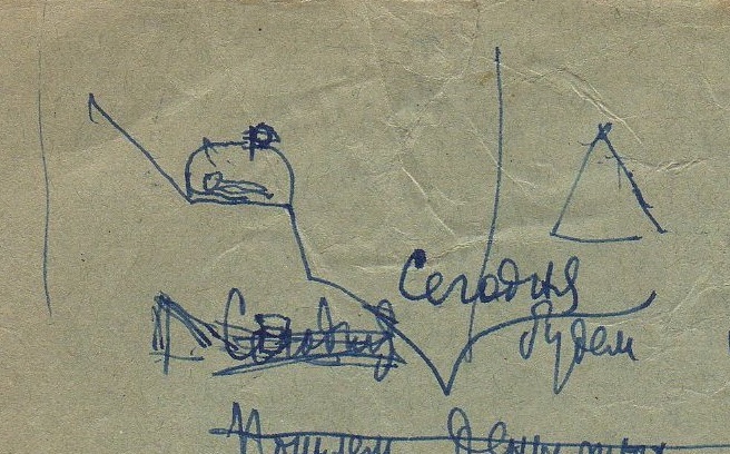
And one more proof of the correctness of the placement of the TL on the terrace (on the "ledge"), and not below, under it in the "pit". In the notebooks of Evgeniy Maslennikov there is the following drawing with a tent, which is located on the "ledge", on its edge, exactly as determined by our research.
Fig. 26. Placement the tent on the "ledge", on its edge; from the notebooks of Evgeniy Maslennikov
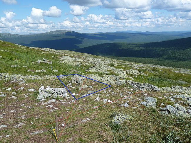
This is what the outline of the tent looks like (the dimensions are not strictly maintained) in a modern photograph. The orientation of the tent may be wrong, in my opinion, up to ± 10 degrees. The yellow arrow shows the direction to the north (magn.), calculated based on true time (using the shadow of the peg) and with an eastern declination of 17 degrees (this is the approximate declination for 1959). As you can see, the entrance of the tent is directed almost to the south, as indicated in the case files.
Fig. 27. Approximate location of the tent outline in modern photographs. Photo by Aleksander Konstantinov August, 2023.
This entire text was published between November 26, 2023 and January 26, 2024 on the forum Dyatlovpass1.ru, and individual parts of this text were published in 2012 on the forum Taina.li
Aleksander Konstantinov

