
20-08-2020
"Appendix zone"
Dyatlov Pass in August 2020
August 23, 2020. All rights reserved Alexander Alexeenkov (Shura)
Photo https://drive.google.com/drive/folders/1dDOEUuwXZ2jdK2wBNXoLtaKFgDnZzPr2
Video https://drive.google.com/drive/folders/1oUDSxtI2HE6zRsmnKxInGkKKr6asbECW
Notes for the AUG 2020 videos:
0000 – panorama from the terrace of the Urochishche pass: Kholat Syakhl, the ridge, 4th tributary to Lozva (4TL), height 905
1 – also larger; 2 – tent and ridge large; 3 – ridge + 4TL large
4, 5, 6 – traces on the right bank of the first creek + 42, 43, 44 – a track of the same footprints
7 – view from left bank of the first creek to: the Cedar, the ledge, the den, where the bodies were found, and the "ficus"
8 – from the same point above the den: view of the triple tree on the path of a possible traverse here from the 4TL bend to the left
9 – possible traverse line (reverse direction)
10 – view of the traverse from 4TL in the forward direction (to the area of the triple tree)
11 – zigzag/deviation 4ТL to the left (north) side of the traverse line
12, 13 – cleared ravine 1st stream
14 – place of bodies + 15, 16 – left bank pocket + 17, 18 – slope of left bank at bodies
20, 21 – camp, crest, view of the mouth of 1st stream from the crest; 22 – zigzag 4TL from this point
23, 24 – the area of the tent; 25...30 - stones with veins
31 – tent, ledge/tongue, shelf, ridge… height 905
32…36 – outlier rock on the southern slope of the Kholat Syakhl, to which the field/gradient was measured with a magnetometer
37 – view from the outlier rock to the outlier rocks on the peaks
38 – view from the outlier rock to the southern pass
39 – southern pass, upper reaches of the Auspiya, a neighboring outlier, from which the field was measured in the opposite direction (to the north)
45…54 – mannequins in the ravine of the first stream (most suitable position/orientation)
55 – description/view from the left bank bush above the bodies and passage from the bush to 4TL with a traverse
56 – traverse from 4TL to the bush above the bodies
57, 58 – Tibo turned 20-25 degrees
59, 60 – Tibo turned 20-25 degrees more – legs are up
61, 62 – Tibo turned 20-25 degrees more
63, 64 – Tibo turned more - up across the stream
65 – stream without mannequins from the same shooting point
Due to various circumstances (I see no point in going into details), the traditional Foundation expedition was cancelled. But three enthusiasts (Shamil Sabirov, Sergey Fadeev, and I) still went to the Pass. On the transfer, Hatfield joined us, but he had his own autonomous plans; on Auspiya he separated from us and followed a path along the river. The trek turned out to be small in composition and short in terms of time (on site – four days for work). At the same time, Shamil had planks for the Otorten area and he returned to us at the Pass on the evening of the third day.
Brief chronology:
2.08.20. In the morning we arrived at Ivdel. There was a hitch here - it took half a day to repair the van we call the "loaf". So the first results are the mastery of replacing the cardan cross and replacing the pump.
In the evening we finally reached Ushma and stayed overnight. With the intention of starting as early as possible in order to reach the Pass by evening.
3.08.20. In the morning the alarm clock failed. It was my fault, I didn't notice how I accidentally set the time to 12-hour mode so it rang at 16:30 instead of 4:30 in the morning. As a result of this misfortune, in the evening one and a half to two hours was not enough to descend from the Urochishche pass to 4TL and set up camp. We are thankful to Valeriy Anyamov who brought our backpacks to the pass, and the three of us walked for almost 6 hours from Ilyich’s base where we got in the morning on the "loaf". We reached the Urochishche pass at 20:00. There, on the border of the crooked forest, we had to stop for the night in the company of numerous jeepers. Descending tired + loaded with backpacks, and even in the twilight/darkness, was fraught.
4.08.20. In the morning, Shamil set off along the road to Otorten, and Sergey and I went to the mouth of the 1st stream. We set up camp and then each went about their own tasks. It was not smart to climb the slope in the afternoon. It’s a shame, but due to the fact that we didn’t have time to set up camp in the evening of the previous day, this day of good weather for working on the slope was lost.
5.08.20 + 6.08.20. We worked with Sergey on the ridge and Kholat Syakhl. Sergey first completed some of his plans at the location where the tent was found in 1959, and then accompanied me. The stress from last year's incident with the bear had not yet resolved, and he was afraid to be alone, either on the slope or in the forest. I am very grateful to him for this "accompaniment", since I was able to give him my camera, gps and other items that I could not carry myself since all the magnetic devices interfered with the correct measurements of the magnetometer.
7.08.20. There were already three of us, Shamil returned the evening before. In the morning we worked in the ravine, then at 12 o'clock it began to rain. We stayed in the tents till to 15:00. By the evening the weather improved a little, Shamil was able to go to the Kuntsevich's campsite on Auspiya and go up to the location of the tent found in 1959.
8.08.20. At 7.50 we set out on our way back. At 20:00 we arrived at Ilyich’s base. We walked for 8.5 hours. It rained all day with varying intensity. Those kilometers back were hard – I was tired. Valeriy met us at the hut and took us to Ushma. On the road we met a bear that was afraid of the car and lazily walked off the road into the forest. The bears there seem to be completely insolent: on the one hand, people leave behind leftover food, and on the other hand, no one scares/shoots the bears. As a result they are not afraid of anything/nobody. Which is scary...
- 2 -
Now about your interests-results.
This time the list of questions was extremely short:
1) magnetometry of the ridge and Kholat Syakhl
2) position of the tree bodies in the 1st stream (mannequins)
3) photo and video traverse from 4TL to the ravine with bodies/den
And a request was added from helga-O-V
4) record tracks on the 1st stream.
1) I'll note right away that I went to this expedition only because of the opportunity to conduct a magnetic survey of the place. Without this, I would not have gone this year. And after they gave me the magnetometer, I would categorically not be happy with any delay or cancellation of the expedition since I was given the device now.
I have been looking for such a device, magnetometer, since the beginning of the year. I asked friends, called several companies and was desperate, couldn't get a magnetometer anywhere. The price of the device was several hundred rubles (several thousands of dollars).
But in a perfectly wonderful way, the question was resolved. The director of one of the firms (my thanks to him) gave me contact in Yekaterinburg. I called the company in Yekaterinburg, I didn't get the manager himself, but talked to one of the employees and realized that the most reasonable thing was to get Kuntsevich involved, he has some clout. I can't ask some unknown stranger from Moscow to get serious people over the phone.
In short, thanks to Kuntsevich and the Foundation, the head of the profile laboratory responded to our request/problem and gave us the device!
I was interested in exploring the NE ridge and Kholat Syakhl for the presence or absence of any inhomogeneities in the geological structure. And the magnetometer-gradiometer MMPOS-2 is just designed for such work.
We used the device on the slopes for two days. My suspicions/expectations were confirmed. A local high-intensity magnetic anomaly was discovered several hundred meters above the place where the tent was found in 1959. To have an understanding of the degree of this "intensity": on the surveyed flat part of the ridge, the magnetic field intensity gradient ranged from a few tenths to units and a half dozen units (nT/m). In the anomalous location it reached 1700 nT/m. That is a difference of several orders of magnitude!
Maps made by the owners of the device based on the measurements obtained:
Completed tracks:

The ridge:

Аномалия:

Unfortunately, we didn't have enough time to examine the slope more thoroughly. And the fact that I came across this "spot" and did not pass very close to the side of it is just some incredible luck! The question is how many more similar "spots" on the slope are there? In any case, on the southern slope of the Kholat Syakhl there is an extended section where the gradient also reached 200...400...700 nT/m. But on this (southern) side of the Kholat Syakhl I managed to pass only two approximately parallel profiles at a distance of 20-40 meters from each other. Unfortunately, no detailed picture has been obtained there. But there is founded reason for further investigation.
The results obtained were shown to professional geophysicists in order to obtain expert opinion. Most likely, additional research will be required to answer the question: what is the nature of this anomaly, what causes it, what can/could its presence entail?
- 3 -
Interpretation of the magnetic survey results by a professional geologist (nickname mogar333 on Taina.li):
I built, so to speak, everything that can be built, in the form of maps or rather plans of the magnetic field for two sensors - upper and lower, namely, the area of the tent and the area north of it and a narrow strip of survey - through the top of the Kholat Syakhl to the outlier on the southern slope. The coordinates, respectively, are in latitude and longitude in meters, so the distortions that were present in the pictures of the owners of the devices disappeared. I chose the standard coloring for the maps for exploration geophysics – blue for positive anomalies, red for negative anomalies (for the owners of the device it's the other way around).
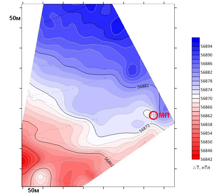
We can see right away that directly at the site of the Dyatlov group's tent there is a calm field, monotonically increasing in the northern direction, that is, there is no fault zone directly at the site of the tent.
But not far from the location of the tent there is anomaly called the "Appendix" zone.

This magnetic field anomaly is typical for the Ural fold system, caused, with a high degree of probability, by the intrusion of serpentinites (ultrabasites). Here is recorded the so-called dipole, a combination of positive and negative anomalies. The "Appendix" zone is essentially a negative dipole anomaly, complicated by positive anomalies.
The increased gradient of the anomaly is due to the presence of local intensely magnetized objects (the fact that the negative anomaly is complicated by positive ones suggests that the boulders of magnetized rocks have slid lower according to the terrain). It should be noted that the anomaly is obviously not contoured in a southeast direction. Of course, I looked at your photos of rock outliers, but firstly, I'm not a geologist, and secondly, even a geologist is unlikely to say anything intelligible based on photographs. Therefore, I concentrated on finding geological information about the area. With difficulty, but I found it.
Having studied the geological map of sheet P-40 and compared magnetic prospecting with geology, some assumptions arise (there is still not enough information for unambiguous conclusions). So, the "Appendix" zone anomaly clearly falls on the northwest-trending fault zone identified by geologists. This dipole anomaly, unfortunately, is not contoured, from the southeast. Presumably - an intrusion of serpentinites, note that the intrusion of serpentinites 2 is located clearly in the same zone as the anomaly you identified. Serpentinite intrusion 1 is also a "semaphorite" indicating that there are enough anomaly-forming serpentinites in this area.

Question: Is it possible to estimate the depth of the source of the anomaly using a gradiometer? And estimate its physical dimensions? And another question arose. Heterogeneity, intrusion, geological fault to which the place is tied - that is, cracks, voids are possible - then, as far as I understand, the release and explosion(s) of gas accumulated in the rocks is possible? And, if the release of gas in such structures is possible, then what kind of gas in relation to this specific geological "interior" of the place can we talk about: radon, methane, hydrogen, or something else?
Answer: I used the program for two-dimensional quantitative interpretation of magnetic exploration to create, in the first, so to speak, approximation, a geological and geophysical model of the anomaly-forming object you identified. I did not take into account the relief, and the size of the anomalies was also taken into account "by eye", but for a fundamental understanding of the overall picture it will do, especially in the absence of a priori information. The observed magnetic field of the upper sensor (the presence of combined positive and negative anomalies) is very successfully explained by the intrusion of hypermafic rocks, gently plunging in the southwestern direction. Anomalous magnetic susceptibility for intrusion (selection) = 200 * 10-5 units in cgs (centimeter-gram-second).
The observed field of the lower sensor is complicated in the area of the negative anomaly (aka the "Appendix" zone) by local intense positive anomalies, which can only be caused by the presence of near-surface inhomogeneities with increased magnetic susceptibility. They, in fact, create the gradient anomalies you identified, since the upper sensor practically "does not see" them. Anomalous magnetic susceptibility for near-surface heterogeneity (selection) = 400 * 10-5 units. cgs.
Since the measurements were carried out with a gradiometer, the option of determining the depth to anomaly-forming objects using the difference between the lower and upper sensor and the amplitude of the corresponding anomalies (with the subtraction of background values) suggests itself. However, for an anomaly, presumably caused by an inclined layer, IMHO, due to this very inclination, things are more complicated. Without going into the wilds, for this anomaly I formally calculated the distance to the center of magnetic mass (from the surface of the earth). It turned out to be equal to 18.5 m, which clearly confirms the geological nature of the anomaly (under any, so to speak, scenarios and interpretations).
For anomalies from the "Appendix" zone caused by near-surface inhomogeneities, the distance to the center of mass does not exceed 0.5-0.8 m. Here, theoretically, of course, there could be some kind of technogenic agent, but given the timing of these anomalies to the likely daytime the surface of serpentinites higher up the slope... IMHO, unlikely.
Regarding possible gas emissions in the pass area, I’m afraid I have nothing to say, this topic is too far from my professional knowledge and interests, so to speak. The only thing that can be noted is that for the accumulation of gases, the presence of a layer of fluid-tight rocks is necessary, so it seems that the area of the pass, where the rocks of the Ural fold system directly reach the surface, is not a very suitable place for the possibility of accumulation of gases and their subsequent releases under certain circumstances, although who knows…
- 4 -
2) Full-size mannequins were cut out and brought to simulate the position of the tree bodies in the ravine. To see/understand how their position fits in with the actual profile of the stream. The most controversial issue was the position of Tibo. Based on this full-scale prototyping, I am inclined to change my previous opinion and agree with what is recorded in case files 341-343:
"All bodies were in the water. They were excavated from the snow from 2.5 meters to 2 meters deep. Two men and a third lay their heads to the north along the stream."
Photo 1270:

The guys’ legs were not up on the left side bank. Taking into account the fact that the bodies were lying on rocks in the water, and not hanging into the water, they could not throw/fall, much less undermine the cornice, with their feet on the steep slope/elevation of the left side protrusion falling here is unrealistic. And in order for Tibo’s legs to be oriented towards the left bank "pocket", it is necessary not only to position it across the riverbed (which is highly suspected from 1959's photo), but to turn the body even further towards the current. But in this orientation, the body noticeably moves down and no longer corresponds to the position of 1959 on the ledge and the presence of a mirror of water below the right hand (it is hidden):
Photo 1310:

Is it possible, having accepted the position "along the stream" recorded in the case files, to draw some new conclusions about the reasons for their such position and possible movements/paths of their getting there. I haven't thought about it too hard. But we should try and do some experiments.
3) The possible traverse from 4TL towards the bodies/den/Cedar was photographed and videoed for clarity and analysis by interested readers. I myself have no doubt that the guys came to the ravine/triple tree area straight, that is, deviating from the 4TL bed, which, zagging to the left, fell sharply somewhere. Watch the video and photos (links included at the beginning of this article).
4) The tracks on the right bank of 1st stream were filmed in the same place as in 2015. The statement of helga-O-V: "it is clear that the place is not conditioned by anything, is not pressed by anything, you can move completely freely in this clearing" - does not correspond to reality:
The right side of 1st stream 1 is very convenient for moving up and down (unlike the left side of the 1st stream or the right side of the 2nd stream, or the center strip between both streams). And in this particular place (where the tracks are) this convenient "sidewalk" on the left side is precisely pressed in on the sides to a width of literally one and a half meters. If you look from bottom to top along the slope, then on the right this convenient passage is limited by a noticeable slope towards the riverbed, and on the left the passage along the flat part is limited by trees. So (with all the vastness - go wherever I want) the animal walks precisely through this narrow place from year to year. There is no harm in ramming through thickets or wetlands. By the way, we are also no exception - we went down and up precisely along this side, in this place. There is nothing surprising in the fact that the tracks disappear higher and lower - there is no pressure there and there is no need to trample on the trail. There is nothing interesting in these tracks, even if the upper edge of the "40 cm tracks" was imprinted (if I caught it correctly) at some time in the past by the claws of a passing bear.
You can discuss this topic on Dyatlov Pass Forum.


