Ravine by Shura Alekseenkov and Sasha KAN

Alekseenkov (Shura) published this information in Russian forum Перевал 1959.
Expedition March 2019 | |
| Photo album 1 | GPS track |
| Photo album 2 | Fall through the cornice: |
| Photo album 3 | Video clip 1 |
| Photo album 4 | Video clip 2 |

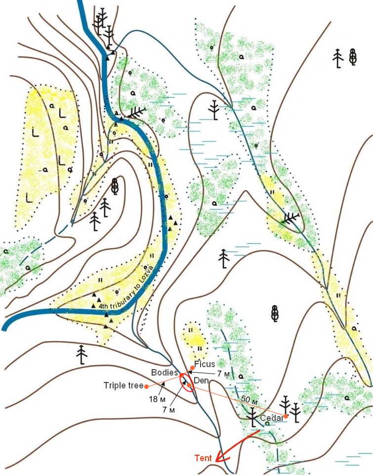
Situation map by Alekseenkov (full map). Marked with red ellipse is the area of the profile.
Contour interval is 5m. There is east magnetic declination of 19°5' not shown on the map.
Click on a name of the landmark for a 1959 photo. Landmarks are listed at the bottom of the page.
More detailed map by Vladimir Borzenkov.

Eastern and western sides of the creek. The green are the banks. Lyuda Dubinina's head is pointing South.
Author: Olga Vedeneeva (ака Helga)

Measurements taken in 2016 KAN expedition
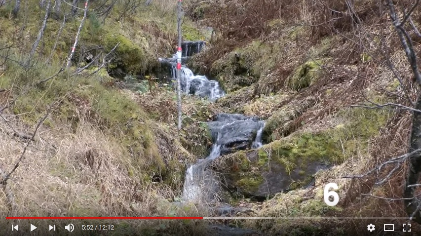
The stick painted in red and white can be seen in video by Alekseenkov (September 2012) embedded below (here is a frame), not to be confused with the pole with red from the photos (2016).
P4 is the stone 3m upstream (South) from the den.
M4 on some photos is where the bodies were found, point "1" on the profile
The video

Resources
GPS coordinates
KAN 2012 expedition
| Cedar | N61°45'53.20" E59°27'17.80" | 647m |
| Mouth of creek 1 | N61°45'55.66" E59°27'13.36" | 628m |
| Mouth of creek 2 | N61°45'59.40" E59°27'15.40" | 618m |
| Р4 | N61°45'53.85" E59°27'14.47" | 641m |
| The bodies | N61°45'53.93" E59°27'14.64" | 636m |
| Triple tree | N61°45'53.58" E59°27'13.75" | 645m |
| Ficus | N61°45'54.59" E59°27'15.06" |
Video
Video by Alekseenkov (Shura)
https://www.youtube.com/playlist?list=...
September 2012. The creek
https://www.youtube.com/watch?v=HFgB2MMEO0s&list=...
5:35 – 6:23: View on bodies-den location from the lower part of the creek
7:52 – 8:20: View on bodies-den location from the upper part of the creek
March 2013. The creek
https://www.youtube.com/watch?v=I_f_F1zTjSw
8:34 – 9:33: View on bodies-den location from the lower part of the creek
11:40 – 12:55: View on bodies-den location from the right (eastern) bank of the creek
https://www.youtube.com/watch?v=1MZiZrzTYIo
February 2014
https://www.youtube.com/watch?v=sH-3jOO9QI0
00:05 – 00:35: View on bodies location from the den location
https://www.youtube.com/watch?v=FAuxkkISqmI
10:52 – 11:17: View from the den location and lower then bodies location
Photos
Photos by КАН in a forum
http://russia-paranormal.org/index.php?topic=4361
Photos by КАН (August 2016)
https://yadi.sk/a/-PKDkWi13VmLts
Photos by Shura (November 2016)
https://disk.yandex.ru/d/WHlFlrvczgE8t
Photos by Shura (March 2013)
https://drive.google.com/drive/folders/1SItU1rA9J5nkOeBpP0-W0XuC4rjIMB5m
https://drive.google.com/drive/folders/1gNnbU0qom3g0lH_r4Pn6VlQ9axXel4kt
https://drive.google.com/drive/folders/10sx-ekTt5GWzcWsPkhqpbgCRNsIGvbub
 1
1
 2
2
 3
3
 4
4
 5
5
 6
6
 7
7
 8
8
 9
9
 10
10
 11
11
 12
12
 13
13
 14
14
 15
15
 16
16
 17
17
 18
18
 19
19
 20
20
Map landmarks
 Triple tree
 Cedar
Cedar
 Ficus
Ficus
 Den
Den


