Borzenkov's analysis of Puzrin-Gaume avalanche theory Comments (3)
14-04-2018
Vladimir A. Borzenkov's analysis of
Post-publication careers: follow-up expeditions reveal avalanches at Dyatlov Pass
Dr. Vladimir Borzenkov has been to the pass many times and examined the snow cover and the avalanche as phenomenon. I reached out for an opinion. He replied with 30 pages with illustrations. All that Puzrin and Gaume didn't do (go to the pass) Borzenkov has been doing in the winter of 2012, 2013, 2014, 2015, and 2019. Dr. Vladimir Borzenkov is a graduate from the Moscow State University of Aeronautics (formerly Moscow Aviation Institute) with degrees in aviation engineering, another in applied mathematics and a PhD in safety and rescue equipment engineering for aviation and space systems. In 1982 Borzenkov was a member of the scientific team behind the first Soviet expedition to Everest. He designed special high altitude suits and an oxygen mask mechanism which was later used in the Soviet space program. This is his analysis on Puzrin-Gaume theory.
 I don't understand the claim of the authors. If this article is about the existence of avalanches in the Northern Urals, then this is not news, there is an area near Mount Otorten where avalanches fall all the time. But what does this have to do with the Dyatlov group? A quote form the article in question:
"Our 2021 study in Communications Earth & Environment1 shows that a snow slab avalanche is a plausible explanation of the 1959 Dyatlov Pass incident."
From this it becomes clear that the authors put an equal sign between their studies of the avalanche situation in the Northern Urals in general, and what happened to the Dyatlov group. The article focuses on the fact that in another place, at a distance of about 3 km (1.8 miles), such a phenomenon was observed. It is so easy to bring all concepts to the point of absurdity, for example, by indicating a point on the globe where everything will merge in one and the same place. How do you apply what you observed to the place where the Dyatlov group tent was found? 3 km is quite a distance to assume that the conditions are the same. By their own logic there was no avalanche a few hundred meters away from where Dmitry Borisov took his photo on March 29, 2021, under the same conditions except for some "little differences". How do you cross over the gap of 3 km (1.8 miles), especially since the conditions there are fundamentally different? I can explain clearly and with specific examples the difference in conditions in these specific places. The main parameters are: a sharp drop in steepness of the slope (1), specific slope steepness (2), wind exposure (3), intensity of snow accumulation (4) - these are the conditions for creating a real avalanche danger, as well as weather conditions for the formation of avalanches (5). These are the conditions necessary for the an avalanche to occur.
It should be noted that if conditions 1, 2, 3, 4 are not met, even if conditions 5 exist, then the avalanche will not take place. Therefore, I will limit myself to this part only. Initially, you need to consider the topography and a more distinct appearance of three places for comparison: "A" the place where the avalanche was photographed by Dmitry Borisov on March 29, 2021; "B" is the place where the tent of the Dyatlov group was found and "C" is the place near Mount Otorten.

Photo №1
This image (Photo №1) shows a panorama of the entire middle part of the main Ural Range in its part called "Poyasovoy stone" - from Mount Khozya-Tolyachakhl in the south (far left) to Mount Otorten in the north (far right). On a topographic map of a large scale of 1:50000, this area looks like in map №1.

Photo №1
Legend:
 | localization of avalanche monitoring points |
 | photo point on the north-eastern spur of Mount Kholatchakhl |
 | photo point on the southern pass near Mount Kholatchakhl |
 | directions for photographing monitoring points |
 | the direction of the main flow of wind and snow transfer, determined by the local topography of the valleys of the western direction |
 | direction of side (oblique, lateral) wind currents and snow transfer, present below the main heights and determined by the local relief of the valleys of the eastern direction |
 | northwest wind according to the weather report for February 01 and 02, 1959 |
 | direction of the northwest wind in the cyclone on February 01 and 02, 1959, due to the Coriolis force |
Some parts of the photos can be considered in more detail. For example, the place where the avalanche was photographed by Dmitry Borisov on March 29, 2021. Avalanches have been observed there in different years. The authors of the article didn't make a "discovery" by spotting an avalanche on this particular spot. There is nothing unique about it. The place was not investigated because it is far from the place of events and has completely different conditions. Although the possibility of avalanches in this particular area was not denied, it has nothing to do with what happened with the Dyatlov group.

Photo №2
March 19, 2013 at 08:35 (UTC+5)

Photo №3
March 11, 2013 at 18:17 (UTC+5)
These photos were taken from approximately the same point as the photo of Dmitry Borisov on March 29, 2021.
You can see this very spot in summer on photos taken from different points. The compacted snow layer from avalanches does not melt until the end of summer, because it doesn't get warm enough. But this is far from the place where the tent of the Dyatlov group was found, and no such traces have been ever seen on the slope where the events took place.
") Photo №4
Photo №4August 15, 2009 at 09:33 (UTC+5)
") Photo №5
Photo №5August 12, 2009 at 11:40 (UTC+5)
") Photo №6
Photo №6August 4, 2009 at 12:37 (UTC+5)
Photo №4 was taken on August 15, 2009 at 09:33 (UTC+5) approximately from the place where the tent of the Dyatlov group stood.
Photo №5 was taken on August 12, 2009 at 11:40 (UTC+5) from the top of the boot rock.
Photo №6 was taken on August 4, 2009 at 12:37 (UTC+5) from the trail in the forest zone when climbing the pass. Тhe summer snowfield of an avalanche descended in winter is best seen here.
A picture similar to the above is observed in another place - near Mount Otorten.

Photo №7
March 11, 2019 at 12:53 (UTC+5)
Photo №7 was taken from the north-eastern spur of Mount Kholatchakhl towards Mount Otorten. The presence of cornices and avalanche phenomena are apparent there, and another common numerator is that they also have nothing to do with the place where the tent of the Dyatlov group was found. The distance here in a straight line is 11 km (, and it is a better example of avalanche danger than the one indicated by Dmitry Borisov. It is a popular hiking destination in winter.
The place where the tent of the Dyatlov group was found is very different in the nature of the terrain from these two places. Photos of the place where the tent of the Dyatlov group was pitched from different angles in different years in winter are presented below - photos №8-16

Photo №8
February 2014. Ascent from below to the place of the Dyatlov group's tent, which is indicated by color flags. If you pay attention to the figure of a person and compare its position with what is shown in photo "d" from Puzrin-Gome publication, then an obvious difference in the steepness of the slope becomes clear, although in my photo №8 the steepness is somewhat exaggerated due to perspective distortions when photographing up with a wide-angle lens. Notice the depth of the tracks in this photo as typical for slightly compacted snow that fell on the day before and earlier that same day.
The steepness of the slope is clearer in photos №9 and 10.

Photo №9 - February 2014
A shot from the side at the point of the tent location in the direction to the north. The steepness of the slope is very clear here. Especially in comparison with photo "d" from Puzrin-Gome the publication. The same can be compared with conditions in January 2015 (photo №10).

Photo №10 - January 2015
Photos №9, 10 and 11, this is the same place where the mock tent was created from snow. Since it was filled with crusted snow, this characterizes its composition for that period, which was no different from any other, when we conducted our research there on 6 different winter expeditions. By the way, the measured density of snow at that time was 458 kg per 1 m3, which corresponds to its average (constant) density in different years with a difference only in the third decimal place of the mass. Photo №11 helps compare the amount of snow in February 2014 and in February 1959.

Photo №11
This photo is a little lower on the slope and shows the snow conditions in January 2015.

Photo №12
It is also necessary to compare the above photos №9, 10 and 12 with photo №13 from 1959 and photo №14 from 2014.

Photo №13

Photo №14 - February 2014
It is visible in these photos that in 1959 the amount of snow on the slope was extremely small, and the ridges were exposed to bare stones. The difference is explained by the fact that over the next 50-60 years the climate became warmer, and therefore the humidity increased, and hence the amount of snowfall. November, in particular, in November 2016, when we carried out the next stage of comparing conditions, can be considered the closest to 1959 in terms of snow accumulation.

Photo №15
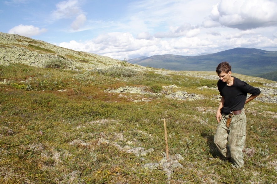
This is a view to the south (photo №15), the place of the Dyatlov group tent is indicated by a seated person. In addition, it should be noted that there was a lot of fresh loose snow on the slope (about 20–25 cm), due to the fact that there were no strong winds for a long time. Otherwise, in any winter month, there is only a hard crust on the surface. Since in the winter months the winds in this place blow constantly with different intensities, but their direction is determined mainly as western, and, which is somewhat less common, northern. Photo №16 is a view looking up from the same place.

Photo №16
On top of photo №16, the ridge of the northeastern spur of Mount Kholatchakhl is already visible at the top of photo №16. The mountain itself is in the continuation of the upper left edge of the ridge. The calculated and verified place of the tent is indicated by a vertical pole in the middle part, to the right in the picture. The elevation of the slope from this place to the top of the northeastern spur of Mount Kholatchakhl is ~40 vertical meters (131 ft), and the angle of steepness of the snow slope (in different years in winter) is 16…17 degrees along the entire length of the slope, to the very top, excluding the last ~5 m, where it increases to almost 20 degrees on the snow cover. We used the simplest measuring tool shown in Photo №17 for the measurement. Its error is approximately +/- 1 degree relative to the error of an industrial calibrated tool.
The length of the supporting part of our tool was 2,5 m (8 ft). The measurements were carried out in February 2014 and in March 2019 along the same line, previously marked by known noticeable landmarks. The difference in the measured angle value was +/-2…3 degrees for different measurement dates. There were local differences in different sections of the slope, but, in general, the changes in the magnitude of the steepness were monotonous.

Photo №17
Here you can see the thickness of the loose snow is about 1–2 cm. The summer slope profile is very different from the winter one, but it does not indicate the possibility of snow movement in any way. This is justified by the fact that starting from October, the deeper parts of the relief are gradually filled first with wet and freezing snow, and then with the regular filling of the depressed parts of the slope with snow, which is then frequently compacted by strong winds that blow almost constantly in this place.
The study of the profile of the snow layer cut along the entire thickness from the top to the ground in different years (2010, 2014, 2015, 2019) did not indicate the presence of weak adhesion of the layers, especially deep frost. The layering of the snow was visible, but the adhesion of the different layers was very strong. The experiment on the shear of snow layers of the most visually weak and deep layer, carried out by us in March 2019, gave such a result that the shear force was more than an order of magnitude higher than the possible force that should shift the layer even if there is a crack (no resistance to separation) of the overlying snow section. I sent the description of the experiment and the results to Puzrin in a letter from 2021.
Find below a few pictures of the area of the tent picturing the same angle as those taken in the winter.
 Photo №18
 Photo №19
 Photo №20
Photo №18 is similar to photo №8. The tent was on a sloping terrace, its location is indicated by an arrow. Noteworthy is the nature of the slope cover. Such roughness will not allow snow to shift in the lower layers. The stones protrude on average by 10…40 cm (4…16 inches).
Photo №19 shows the terrace on which the tent was located. The slope here is about 5 degrees. In winter, there is the thinnest part of the snow cover, which is from 40…70 cm thick (16…28 inches). Vladislav Karelin who was member of the search party in 1959 says: "The skis under the tent at one end practically lay on the stones." This means that the place of the tent should be moved to the right (slightly east), to the fold of the slope down, where the angle increases. In summer, this angle, which is located down the slope, is approximately 20 degrees. But the further continuation of the slope is uneven, since it consists of large stones, such as those seen in photo №18.
Photo №20 shows the profile of the uppermost part of the slope, which overlooks the sloping part of the top of the north-eastern spur of Mount Kholatchakhl. The mountain itself can be seen in the center of the photo, at the top. The photo was taken at a mark 30 m above the place where the tent stood. In winter, everything is leveled with snow, as seen in photo №16. Please note that the localized steep section in the middle of the picture to the right is very steep, but it is so small relative to the length of the slope that it makes no sense to consider it as an "avalanche trigger". This will be indicated below, when considering the computer construction of slope shown in diagram №8. The full picture of the mountain landscape on the section "tent site - watershed of the main Ural ridge" in the direction of the northwest can be seen in photo №21. The heights are dominated by northwest wind, which brings the main precipitation.
Photo №21 shows the obstacles that the wind transporting the snow overcomes when precipitation is brought by the northwest wind. The highest point is on the watershed of the main Ural ridge (943 m). After the stream crosses the main Ural ridge, part of the precipitation falls in the valley of the 2nd right tributary of the Lozva River, and another part in the valley of the 3rd right tributary of the Lozva River.

Photo №21
If you construct a slope profile (profile №2) along the purple line, you can see the change in the profile in the direction of the wind and how the wind currents are distributed in this area.

Profile №2
Noted on the profile:
On the y-axis is indicated the height of the relief above sea level in meters.
The green line shows the profile of the section on this interval.
Light blue thin lines indicate the approximate wind flows in this area.
Each region of the eddy zones of these flows contributes to snowfall at the place where the eddies occur. The same thing happens in the zones of ascending flows, which arise due to changes in the height of the relief.
When the precipitation approaches the northeastern spur of Mount Kholatchakhl, behind which the tent was set up, it is already significantly depleted in terms of the intensity of snowfall. This explains their small amount, relative to what usually falls on the ridge, or immediately behind the main Ural ridge, that is, where the wind overcomes the ridge as a single obstacle. The most interesting for assessing snow accumulation is the nature of the winds in the area where the tent was located, which were observed there at altitudes close to the height of the watershed of the northeastern spur of Mount Kholatchakhl, behind which the tent was set up. This is 100…120 m below the level of the watershed of the northern spur of Mount Kholatchakhl, and everything there is determined by the aerodynamics of the surrounding terrain. The lower layers of the wind flow (located below the heights of the main Ural Range) are directed by the location and direction of the valleys, both from the western direction, and by interaction with the valleys of the eastern side. As well as the flow around Mount Kholatchakhl itself. The pattern of local winds of the northwestern direction revealed by observation is shown in map №3.

Map №3
Thin solid blue lines indicate the streams passing from the western side of Mount Kholatchakhl at the height of the watershed line of the main Ural Range for this area (the pass is north of the mountain itself). Most of the flow goes into the valley of the Lozva River (the third right tributary). However, some, a small part of it, circling around the mountain, flows into the fourth right tributary of the Lozva River. At the very top of it was the place where the tent was located. This part of the flow is depicted with a thin dotted line. Numerous observations indicate that with northwestern and western winds, the wind is always blowing almost exactly in the western direction (directly at the slope surface). That is, at a height of 0…2 m. This was obtained by numerous observations in the winter. The stratification of the wind in height under conditions of such a complex relief is very diverse, and this distribution has not been studied. Any calculation using the general wind model will always give an error. Since the lower part of these flows is not taken into account, therefore, the conditional "boundary layer" can be determined at least 10…20 m in height above the level of relief and vegetation in the lower part of the slopes.
We can use the values that are given in the work of Professor Galina Pigoltsina, which are calculated on regional climate models for the Northern and Subpolar Urals. These values are in good agreement with what I calculated with simpler and more approximate methods for this area in 2008, using the values of weather parameters from 9 nearby weather stations. Additionally, it should be understood that such wind speeds, as well as the smooth and rounded relief of the northeastern spur of Mount Kholatchakhl, do not allow the emergence of cornices and the growth of a large cushion of loose snow. Even at high wind speeds. In this, Galina Pigoltsina has a big and fundamental mistake, since she is not familiar with this particular place in detail. How true this is can be understood from the maps of this place, the photographs and diagrams created based on the results of observation, measurements and analysis of the situation in six special winter expeditions.
The largest amount of loose snow in our 6 winter expeditions (lasting 5…9 days each) was measured at 30 cm, after three relatively calm days, when the wind speed in the treeless zone was only 1…3 m/s. But such periods are relatively rare. Generally there are constant winds with an average speed of 12…15 m/s. Often there are winds of 20…25 m/s, and sometimes more than 30…35 m/s. For example in January 2015 there were constant winds of 20…25 m/s and on the last day of our stay the wind reached a speed of 36 m/s. Therefore, loose snow does not linger there, and those quantities that fall into the ruts and are retained by obstacles are quickly compacted to a crust. The picture of snow deposition and the possibility of cornices is very different from the place that Oleg Demyanenko and Dmitry Borisov cite as "proof" of the possibility of an avalanche in the case of the Dyatlov group.
I will write about the conditions at that place further down.
First, as more important, I want to explain the snow situation at the place where the tent of the Dyatlov group stood. If you draw up a schematic diagram of filling this slope with snow, for example, to the level shown in the photo of January 2015 (Photo №15), it can be like on diagram №4.

Diagram №4
The nature of the snow transfer of the slope of the northeastern spur of Mount Kholatchakhl for the period from October to January. The deposition and accumulation of snow is typical for January 2015, and it is practically no different from the winter of any other year.
During the period of autumn formation, the hard crusty snow of the slope remains concave (dark blue line in diagram №4). Often at that time falls wet snow and soon freezes. By January the slope is already leveling off. Winter measurements of the snow depth in February 2014 gave a snow thickness from 80 cm (27 in) at the tent site to 2.2…2.5 m (7…8 ft) at a distance of about 20 m (65 ft) from the start of testing towards the northeastern spur of Mount Kholatchakhl. After that the length of the three-meter probe was not enough. The snow was hard crust throughout the indicated measurement range.
Please note that in the course of time the slope is gradually filled with snow, first forming a depressed slope (this occurs during November and part of December - it is shown by a dark blue line), and by the first decade of January the slope is almost flat (with sastrugi) and stays that way all winter. This must be taken into account when building models and analyzing the adhesion mechanics of different layers. The depressed layers create additional resistance even if conditions arise for sliding above the layer of snow.
The actual cutting of the slope does not correspond in any way to what is given in the initial conditions for the occurrence of an avalanche in Puzrin-Gaume article. I don’t know how familiar they are with the practice of cross-country skiing in Russia of that period (late 50s), but in treeless areas on slopes of varying steepness, tents were set up on the principle of least work with maximum camp safety and overnight convenience. The Dyatlov group found a platform along the level line, marked out the required size (4.5x2 m or 14x6 ft), and leveled the platform under the bottom of the tent This was done with the help of skis, which loosened and raked the snow. A similar operation is shown in photo №22.

Photo №22
Very often the snow was not removed to the full width of the tent. Usually the site was made smaller by about 1/4 of the width, since an additional part could be obtained by compacting the snow that was removed up the slope. This saved the corresponding part of the work. If we consider the conditions in 2014 to be similar to 1959 (although according to the available information, less snow was accumulated in 1959 which means less steepness), then the required height of the snow cut should be 40…55 cm (16…22 in) (it turns out to be different in length for a tent). On photo №23 the ski is shortened to 75 cm (30 in), which we specially took for closer to the original conditions experiment.

Photo №23
Based on the combination of snow cover thickness, the conditions listed above and the steepness of the slope, it becomes clear that any movement of snow here is almost unbelievable. If you try to determine the probability, then it turns out to be equal to that all the water molecules in a glass suddenly begin to move upward at the same time and the water "jumps". Lets compare the conditions with the place in the photo Dmitry Borisov took on March 29, 2021 (A). Here is the section of the map of this area, depicted on map №5.

Map №5
Photo №24 is taken from the Boot rock (outlier rock with the commemorative plaque) on the southern pass of Mount Kholatchakhl.

Photo №24
When compared the conditions in these places are completely different.
- The place where the avalanche is shot by Dmitry Borisov on March 29, 2021 (photo "d") has a pronounced cliff shape. That is, the change in the angle of the slope in the direction of the wind from the west is very sharp.
- The steepness of the lee slope is much more than 30 degrees, and judging by the photo Dmitry Borisov took on March 29, 2021 photo "d"), it exceeds 45 degrees. This can be seen from the fact that a person standing on a slope easily touches the surface of the snow with his hand, without even leaning towards the surface.
- If we use the human in the photo for scale we can say that the thickness of the detached layer of snow is close to 1 meter if not more.
- From the scheme on map №4, it is clear that the currents of air carrying snow have no obstacles either in front of this pass, or on it, or after crossing the watershed line, and then immediately flow into the valley of the Auspiya River, in a powerful stream. The absence of side currents in this place contributes to the fact that the entire mass of snow carried by the airflow, due to its turbulence at a sharp drop in the steepness of the slope, is deposited on the steep part and contributes to the formation of cornices.
There is nothing like that in the vicinity of the place where the tent was set up by the Dyatlov group.
If we draw up a scheme for the deposition and accumulation of snow in this place, similar to the scheme on map №4 we get a picture that is shown in diagram №6.

Diagram №6
Legend:
А - А conditional baseline for the upper part of the slope.
Н => Top of the slope (~100 m or 328 ft), which corresponds to about half of the full height (to a relatively flat part =250 m or 820 ft).
h1 => visible in the photo of Dmitry Borisov taken on March 29, 2021 (photo "d") snow break height (~1,0 m or 3 ft),
h2 => estimated thickness of accumulated snow capable of falling in an avalanche (>> h1).
In the literature in English, I found a fairly good description of such processes in the book G.Seligman. Snow Structure And Ski Fields. Macmillan and Co, Ltd. London, 1936.

Snow Structure And Ski Fields
The third place (C), has the same conditions that I just described for the southern pass of Mount Kholatchakhl. Similar conditions and the same exact view is observed on the cliff near Mount Otorten. Probably, it is even more pronounced there, but snow cornices fall more often than avalanches due to accumulation and descent of large masses of snow.
There is a large drop from the edge of the cliff to an almost flat part and a steep part of the slope that is large in height. This is shown on map №7.

Map №7
In table №1 is presented a comparison of some of the most important conditions that characterize the avalanche situation in these three places:
| South pass | Tent site | Cliff near Otorten | |
| (A) | (B) | (C) | |
| Steepness of the slope at the edge of the inflection | ~30…45 degrees slope is steep and precipitous | 16…17 degrees* gently sloping | ~25…30 degrees slope is steep and precipitous |
| Terrain change | sharp | gently sloping | sharp |
| Slope height above flat part or identified location | 150 m and more | ~40 m | 250 m and more |
| Additional flow obstructions | no | 2 valleys across the stream, the circulation of the stream around the mountain | no |
| Horizontal flow change | practically absent | significant | practically absent |
| Snow deposition with wind | high | practically absent | high |
| Snow accumulation assessment | large, 1 m and more | upto 30 cm * | large |
| Cornices | yes | no | yes |
| Deep frost | no data | no (over the observation period) | no data |
| Sliding snow cover | constant | no | constant |
* measured value
Table №1
If we sum up the comparison of all the characteristics of the three places relative to an avalanche phenomena, the conclusion is that an attempt to apply same avalanche model to all three locations would be a big mistake. Therefore, it would be very frivolous to argue that the cause of what happened to the Dyatlov group could be an avalanche or its varieties.
In the concluding part, I would like to express some objections directly to the text of Puzrin-Gomey's article. In the article, I found a number of statements that are either ambiguous or completely wrong. I'll give just a few excerpt below.
Quote:
"The direct evidence from the Dyatlov Pass area obtained in those expeditions confirms that the region is avalanche prone and that slopes above the location where Igor Dyatlov and his group pitched their tent are steep enough for avalanches to release."
This is an example of an ambiguity transitioning to a false statement. The avalanche danger of the area is only in one, specific place, depicted in the photo of Dmitry Borisov on March 29, 2021. However, the place "where Igor Dyatlov and his group pitched a tent" is completely different. You can not simply interpolate* the conditions from 3 km (1.8 miles) distance away, the difference in the conditions is very significant to ignore.
*Interpolation: In the mathematical field of numerical analysis, interpolation is a type of estimation, a method of constructing new data points based on the range of a discrete set of known data points.
Quote:
"Using basic physics, we showed that in spite of a lower-than-usual apparent slope angle, scarcity of avalanche signs, uncertainties about the trigger, and unusual injuries of the victims, such an avalanche is indeed a possible explanation."
I cannot agree with this statement, especially with the highlighted passage. The vast majority of fatal injuries in avalanches are asphyxiation from snow barriers to breathing, multiple injuries to limbs, and body lacerations from being dragged by snow flow over rocky obstacles within the snow slide. There are no signs of such injuries in the autopsy reports of the Dyatlov group. Additionally, to my knowledge, the statistics show that if an avalanche surprises a whole group inside a tent, they usually don't make it out of the tent at all. I have a first hand experience working on several similar cases.
Quote:
"One important ingredient of our proposed mechanism is the progressive wind-blown snow accumulation on the slope above the hikers’ tent."
This doesn't apply to the location of the Dyatlov tent although perfectly fair for the place that you indicated in your article (A). That place is fundamentally different from the Dyatlov tent location, where there are no conditions for the accumulation of a large amount of snow. My arguments are presented with diagrams earlier in this article.
Quote:
"Equally significantly, the topography of the slope is irregular, built of 4-to-6 m-high steps: although the average slope inclination (observed when the steps are covered by snow) is indeed too low for an avalanche to release, we assumed (based on the evidence available at that time), that a locally steeper slope above the tent had an inclination of at least 28 degrees."
On the slope above the Dyatlov group tent there are no cornices in winter. Practical measurement of angles on snow in 2 different winter periods in different years shows angle values of 16…17 degrees, with local (up to 2.5…5 m or 8…16 ft along the formation) increase up to 20 degrees.
If I understand correctly your digital elevation model section A - A is of the slope where Igor Dyatlov and his group pitched their tent?
If the vertical and horizontal scales are the same, then it is necessary to consider look at the profile in greater detail. I made a calculation (based on my assumption), which I shown on Diagram №8.

Diagram №8
Even if we neglect the fact that during autumn and the beginning of winter (October - January) all the concavities of this slope are filled with hard snow to an even slope (which I have already mentioned above), then consideration of the rocky profile of the slope also makes it possible to doubt the possibility of snow melting on any significantly large (within 5 m) section of the relief. The sizes of the plots, both 30-degree and 20-degree slope, are indicated on my diagram №8. They are so insignificant in size that it makes no sense to consider them seriously. And I pointed out the nature and appearance of such areas in Photo №19.
I put down the basic dimensions according to the results of our measurements, they almost coincided with your model. The exception is the height from the place of Dyatlov group tent to the very top of the spur, taking into account the snow cover (!??). Compared to our measurements, the difference is 5…7 m, which cannot be attributed to the thickness of the snow on the almost flat top of the northeastern spur of the mountain. The only time we measure the thickness of the snow there gave a result of less than 2 m.
I do not consider this to be fundamental, since the slope itself and its real profile for winter conditions are decisive for the presence of snow slabs, and not the thickness on the flat part of the spur.
The hypothetical snow slab in sections with a steepness of 30 degrees is also unrealistic, since immediately after such an area there is a flat part of approximately the same size. Even without taking into account the small dimensions, which are the largest in length according to the selected line A - A.
I have no information that someone else has done the same measurements and in general a detailed study of this particular place. Even the expedition of Sergei Semyashkin in 2010 (I advised them and wrote the assignment) made only 2-3 local measurements, but in a different place, with an error of about 100 m from the actual location of the tent. Prof. V. Popovnin took part in the the expedition of the Prosecutor's Office of the Russian Federation in March 2019 and they measured a yet different location but with the same error margin. They measured the steepness of the slopes at no more than 1-2 places, and not along the entire length of the slope. And it is also important that the error in determining the location was about the same 100 m. The surveyors there stated the error of their method of determining the location at +/-50 m. This is a completely unacceptable accuracy for determining the position of the tent site.
Quote:
"The main objections to our conclusion of a snow avalanche were: (i) there was no snow cover on the slope, (ii) there was no wind that night, (iii) there is no significant snow transfer by wind in that area, (iv) the slope is flat (no steps), and (v) snow avalanches never happen in this area."
If this is a reference to my objections from previous letters to Puzrin, then he is mistaken. I wrote about the relative calm during the accumulation of snow at 30 cm in 2013 for only 3 days, when the snow was not blown off the slope, as happens almost constantly.
And the fact that there is no significant accumulation of snow, as well as that the slope in winter is even and (iv) the slope is gentle (without steps) - this is a fact for this place (!). And the fact that "(v) SNOW SLIDES HAVE NEVER BEEN OBSERVED IN THIS PLACE(!)" is my literal statement! I didn’t talk about the entire region, because this has nothing to do with what happened to the Dyatlov group. Moreover, I pointed out to you that there is a place where this phenomenon exists 11 km from this place. I repeat once again that we also observed some snow phenomena from afar, including on the southern pass of Mount Kholatchakhl (also mentioned above). But this is too far from the place of the Dyatlov group tent, and we not interested in these other locations.
Quote:
"Professor Victor Popovnin at the Moscow State University, a leading snow avalanche researcher in Russia, confirmed that the assumptions on the snow properties that we used in our models are consistent with his measurements during a winter expedition to Dyatlov Pass in 2019."
Here the authors are wrong. The respected by me Viktor Vladimirovich Popovnin, conducted only a part of those experiments at the place under study, which he himself recommended to me 4 years before. He studied: the structure of the snow, the distribution of different layers and their boundaries, the depth of the snow, the approximate steepness of the slope (at one point!) And the presence of wind. I did not find a documentation that it was measured with some kind of device.
We were on location that same 2019, only 5 days earlier, and on top of what he was researching we carried out the following additional studies: measuring the temperature of the snow layers at 9 points, measuring the snow density for all 9 layers, and proceeded with a test to slide off a test fragment (20x20 cm at a human height) along the boundary of the weakest (empirically selected) layers.
Compared to Popovnin, the only study we couldn't carry out was of the different snow structures - because the wind was constantly blowing away samples of snow fragments from the sheet.
We also did not measure the indentation strength (we did not have a dynamometer working in compression). But Viktor Vladimirovich Popovnin didn’t do it either, if I’m not mistaken.
Unfortunately, Popovnin conducted his research on location only once and only for 1…3 hours.
Quote:
"The second scientist, Professor Galina Pigol’tsina at the Voeikov Main Geophysical Observatory in St Petersburg, reports that during the night of the incident, 1st–2nd of February 1959, the snow cover above the tent exceeded 150 cm, consistent with our assumptions."
This statement is purely theoretical and highly erroneous. She calculated this on the basis of the climate model of the Black Sea coast of the Caucasus (before the 2014 Winter Olympics), where there are completely different climatic conditions. In addition, the respected Professor Pigoltsina does not know the specific details of this area, in particular the relief and aerodynamics of this area. Therefore, her calculation of wind speeds coincides with what is available at a height of 10…20 m above the surface level. Below (near the surface) there is a picture that is very different from these values. The temperature will more coincide with what is in reality, but the influence of a colder lower stagnant layer (due to the presence of vegetation) of the eastern slopes of the Ural Range for a local area below the border of the forest zone is not taken into account. This is very clearly visible directly on the spot, but more global models, on the basis of which the calculation is made, do not take into account such a difference. They have a too rough approximation when compared with the observed picture directly on the spot. I gave you links to video clips of observing wind speeds for individual parts of the slope. Starting from a certain point, the wind speed begins to decrease to almost zero. This place is positioned a little higher than the place where the member of the Dyatlov group closest to the tent was found.
Quote:
"Moreover, the snow transfer by wind during winter in this area can reach 600–1000 m3/m, which would completely cover local topographic features such as the steps."
These are global estimates for the entire region and for a very wide transfer zone across the ridge. Even an estimate of the transfer observed at a particular location in the most difficult weather conditions does not give such values in the +/- 500 m band at a particular location. There, these values are more than an order of magnitude smaller. Moreover, with winds even of 12…15 m/s and more, snow in the treeless zone does not linger on the surface of the previously formed crust layer.
Quote:
"Astonishingly, her best estimate of the wind velocity above the tent was 9 to 12 m/s, right in the range required to explain the observed delay in the slab avalanche release in our model."
This is a more or less real estimate of wind speed, only slightly underestimated. According to my estimates in 2008 and observations on the spot (which was confirmed), the average statistical wind speed in similar conditions of a weak cyclone is 15…18 m/s directly at the place of the Dyatlov group tent. That is, in a treeless zone on the slope of Mount Kholatchakhl.
Quote:
"The summer expedition, however, was equipped with a drone that allowed us to produce a high-resolution threedimensional digital model of the terrain in the vicinity of the possible tent locations (Fig. 2). Clearly, the steps have inclinations exceeding 28 degrees, and many slopes are even steeper than 30 degrees. What’s more, these slopes are not just local, they are continuous: no matter where you pitch your tent you are likely to be below one of them."
Quote:
"Digital Elevation Model (DEM) showing the local slope angle. The DEM was obtained based on a drone photogrammetry analysis (summer 2021 survey) and has a resolution of 9 cm. b A–A′ section showing that although the average slope angle is around 20°, locally steeper steps have indeed an inclination exceeding 30° (given as an indicator by white dashed line)."
I already comment on this, in order to resist the shift of the snow layer directly over the stones, one must also take into account the very large roughness of large stone scree, which is clearly visible in photo №19 and photo №17. I repeat again: sections with a steepness of 28…30 degrees have a very small linear size (literally within no more than 5…6 m) and their location is very scattered. And this is very clearly seen in diagram №8.
Quote:
"Contrary to multiple claims that snow avalanches have never been observed around this area, in two subsequent winter expeditions within the year since publication of our article, we can report several documented slab avalanches in an eastern slope <3 km away from the Dyatlov group tent."
I am asking to correctly perceive my objections: if we are talking about the case with the Dyatlov group then we need to examine a specific location, not the surrounding area. I don't understand why you need to use the Dyatlov case as a headline in the press. The task of studying avalanche phenomena in the Northern Urals is a separate topic that should not be linked to the Dyatlov pass incident. The task of investigating the entire region has very noble goals, and it is valuable from a scientific point of view, since regular and detailed studies have not been carried out there. But I have a lot of data for the specific location where the Dyatlov group tent was found..
Тhere are many avalanche prone slopes in the Northern Urals, not just the the one photographed by Dmitry Borisov on March 29, 2021. The western slopes are especially unstable due to the bigger snow accumulation. But this does not mean that the place of events with the Dyatlov group is also avalanche-prone. Moreover, this does not mean that such a phenomenon took place anywhere in the area at the time of the incident in 1959.
A well-known researcher of the Dyatlov case - Alexey Koskin, who traveled many times to this area (from Mount Isherim in the south, in the western part of the ridge to Mount Koip in the very north of this part of the Urals) told me that he could point at about 10 more places with a very high chances for an avalanche breaking in winter. But he adheres to the same opinion as mine, with which the participants in the search operation of 1959 also agree.
The distance of 3 km (1.8 miles) is very large, in order to be able to generalize everything in between. Then why not take a distance of 300 km (the region of the Subpolar Urals), where avalanches are constantly observed and very powerful ta that, or 3000 km away (all the way to the the Himalayas)... This is, of course, a joke, but having a deep meaning.
It is hardly legitimate to assert that if there are avalanche phenomena on both sides of the designated area, then they also exist in the middle. This is like if two people living at different ends of the street are recognized by the court as criminals, then everyone who lives between them is also a criminal.
Quote:
"Some of the conditions leading to the avalanches observed on 29th January 2022 were very similar to those experienced by the Dyatlov group: eastern slope aspect, date in the year, low temperatures, strong winds and large amounts of wind-transported snow. Other conditions were different: the slab was softer, the slope was steeper, it was not undercut from below and the trigger was probably different, too."
No, this is not correct at all. All specific descriptions of the difference have been given above, in the main text of my presentation. If we continue this logic of comparisons, then the entire region where my country house is located can be considered avalanche-prone, although there is an absolutely flat area. If you follow what is shown, for example, on photo №25.

Photo №25
If the height of the garage wall is 2.6 m, then the height of the piled snow is 2 m or even more.
There are about 250 m3, or even more, if you estimate approximately everything that came off the roof of my house.
Quote:
"Nevertheless, the area is clearly avalanche prone, and the avalanche danger on the night of February 1st, 1959 was real."
This is the same assessment that I just compared with the criminals living at different ends of the street.
There are no real parameters of weather and snow to say so. It's like replacing the concept of "specific place" with "district". There was no such phenomena even as close as 300…500 meters from the place where Dmitry Borisov photographed the avalanche on March 29, 2021, leave alone 3 km away.
Quote:
"Time and again, we were asked whether our article brings to an end our work on the case. We always responded that, although the case itself remains open, our part is closed: we did not want to spend the rest of our lives trying to solve the Dyatlov Pass mystery. One year later, we are no longer so sure. If someone asks, we will refrain from an answer."
Reseraching avalanche phenomena in the Northern Urals region and solving the Dyatlov pass incident are two different concepts. Overlapping these concepts (especially in the press) leads to a misperception by readers of what you write about. Novice readers unfamiliar with both of these aspects are left with the wrong picture of what happened.
It sounds like Puzrin and Gaume need an incentive to attract readers to their publication.
Related articles
 Puzrin and Gaume
 Avalanche 2023
 Dyatlov Pass is a clickbait
 Caroline Detry
 Karelin: Avalanche is a myth
 Was there an avalanche?
 Ptitsyn recollections
 There was no snowstorm
 Materials from the new investigation
 Results of the Investigation


However, the Russian authorities have insisted that the Dyatlov Pass tragedy was caused by a natural disaster even if they know otherwise. There is a reason for that.
The nine group members were all murdered, and they were murdered by professional killers in an intelligently planned operation designed to look like an "accident." The injuries found on the bodies are consistent with human attack, for example the crushing of rib cages are indicative of jiu jitsu techniques used by special forces to incapacitate victims.